
What is recorded here
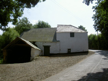
Milltown seems to have turned its original entrance into a window and put a doorway elsewhere. That’s a magnificent way to deal with unwelcome callers: let them reach the usual spot, then draw the curtains in their face.
Rectangular house (max. ext. dims 18m by 6m), two storeys high, constructed of mud walls faced with stone; it has two chimneys and a half-hipped roof thatched with barley straw. The front faces ENE and has two bays (Wth c. 2.1m, D c. 0.65m), one of which has a doorway and the other a window. The northernmost one, which has the windows, appears to have been the original doorway and is almost central to the front, whereas the present doorway is to one side and is almost certainly a later addition. There are four rectangular sash windows at ground-floor level at the front of the house and two at the rear. The upper storey has three at the front and one at the rear. A centrally-placed staircase rises to the first floor and a loft over. A shed was attached to the S gable at the a later date and a back door with porch at the S end of the wall. 2/1999).
Rectangular house (max. ext. dims 18m by 6m), two storeys high, constructed of mud walls faced with stone; it has two chimneys and a half-hipped roof thatched with barley straw. The front faces ENE and has two bays (Wth c. 2.1m, D c. 0.65m), one of which has a doorway and the other a window. The northernmost one, which has the windows, appears to have been the original doorway and is almost central to the front,…
From the National Monuments Service (Archaeological Survey of Ireland) record LH018-052
The monument record does not grant public access. Check the route and ask the landowner before entering private land.
- What survives
- Recorded monument
Places near here
Photo credits
- National Inventory of Architectural Heritage
- Kieran Campbell, Geograph · CC BY-SA 2.0
- Kieran Campbell, Geograph · Creative Commons Attribution-ShareAlike 2.0
- Maker named on the Wikimedia Commons picture page · CC BY-SA 3.0
- Sitomon, Wikimedia Commons · CC BY-SA 2.0
- Garry Dickinson, Geograph · CC BY-SA 2.0
- Oliver Dixon, Geograph · CC BY-SA 2.0
- Andreas F. Borchert, Wikimedia Commons · CC BY-SA 4.0
- Adriao, Wikimedia Commons · CC BY-SA 4.0
 mill (water)64 yd
 IndicatedHouse, 18th/19th century · 629 yd
 Graveyard in DysartGraveyard · 1737 yd
 Sweet bay1.1 mi
 BarmeathCastle, tower house · 1.1 mi
 European Yew1.2 mi
 IndicatedCastle, tower house · 1.3 mi
 ToberanelshyHoly well · 2.8 mi
 IndicatedGraveyard · 3.7 mi
 Port OrielPicnic place · 4.0 mi
 MonasterboiceEarly monastic site · 5.2 mi
 Muiredach's High CrossHeritage attraction · 5.2 mi
More historic places in County Louth · All of County Louth
What do you know about this place?