What is recorded here
The Mill in Milltown gave the whole place its name and then retired to become a store. A magnificent exit: do one job, insist everyone keeps talking about it, and spend the rest of your days holding a few things.
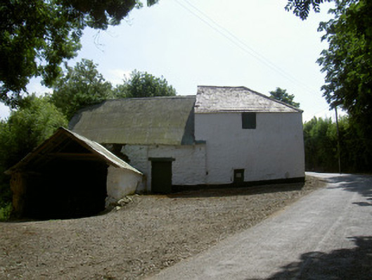
Detached single- and double-height and two-storey former corn mill complex, built c. 1800, now in use as store. Rectangular main building, lower pitched roofed extension to east, single-storey mud-walled building to north, freestanding two-storey pitched roof building to south. Pitched and hipped slate and corrugated-iron roofs, clay ridge and hip tiles to slate roofs, small gabled dormer to south of main building, no rainwater goods. Lime-washed random rubble and unpainted random rubble walling to main structures, mud walling to north building. Square-headed window openings, painted timber vertical-sheeting to openings. Square-headed door openings, painted timber lintels, some with red brick surrounds, painted timber vertically-sheeted doors, door to gable on east elevation of south building accessed by slate and stone partially rendered steps. Gravelled area to north, cobblestones running around base of structures, mill building situated to west of rural country road.
This fine set of mill buildings offer architectural as well as historical interest as they give the area the name 'Milltown'. The retention of many notable features, such as the door with attractive wrought-iron door furniture, and materials, especially the attractive exterior stone stairs and slate roofing, enlivens the structures.
From the Buildings of Ireland (National Inventory of Architectural Heritage) record 13901814
This does not grant access. Most recorded buildings are privately owned; view them only from public ground unless the owner allows entry.
Places near here
 MilltownHouse, 17th century · 64 yd
 IndicatedHouse, 18th/19th century · 650 yd
 Graveyard in DysartGraveyard · 1.0 mi
 Sweet bay1.1 mi
 BarmeathCastle, tower house · 1.1 mi
 European Yew1.2 mi
 IndicatedCastle, tower house · 1.3 mi
 ToberanelshyHoly well · 2.7 mi
 IndicatedGraveyard · 3.8 mi
 Port OrielPicnic place · 4.0 mi
 MonasterboiceEarly monastic site · 5.2 mi
 Muiredach's High CrossHeritage attraction · 5.2 mi
Pictures: Kieran Campbell, Geograph · CC BY-SA 2.0; Kieran Campbell, Geograph · Creative Commons Attribution-ShareAlike 2.0; Maker named on the Wikimedia Commons picture page · CC BY-SA 3.0; Sitomon, Wikimedia Commons · CC BY-SA 2.0; Garry Dickinson, Geograph · CC BY-SA 2.0; Oliver Dixon, Geograph · CC BY-SA 2.0; Andreas F. Borchert, Wikimedia Commons · CC BY-SA 4.0; Adriao, Wikimedia Commons · CC BY-SA 4.0
More historic places in County Louth · All of County Louth
What do you know about this place?