
What is recorded here
From the National Monuments Service (Archaeological Survey of Ireland) record LH008-106
Places near here
Photo credits
- Maker not stated on source page, commons.wikimedia.org
- Maker not stated on source page, irisharchaeology.org
- Eric Jones, Geograph · CC BY-SA 2.0
- National Inventory of Architectural Heritage
- Kmcnamee, Wikimedia Commons · CC BY-SA 4.0
- Maker not stated on source page, www.irelandbeforeyoudie.com
- Maker not stated on source page, ar.pinterest.com
 Fairy fort / earthen ringfort in Rath (dundlak Lwr By; Carlingford Par.)Fairy fort / earthen ringfort · 308 yd
Explorer Tom Rath’s fairy fort was saved by a hero nobody remembers who just really liked mud. The two degraded banks are still…
 Fairy fort / earthen ringfort in Rath LowerFairy fort / earthen ringfort · 508 yd
Explorer Tom Rath Lower is in a bitter rivalry with every other famous fort because it’s got 'Lower' in its name. It’s a scarped…
 Grange Abbey (in Ruins)Church · 567 yd
Explorer Tom Grange Abbey holds a long grudge against the weather for turning it into a castle ruin. It was fortified later, which…
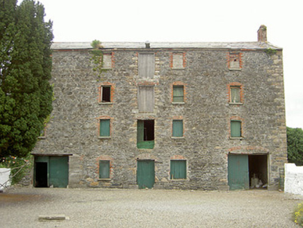 granary672 yd
Explorer Tom Granary in Monksland has a retirement plan that involves turning into a trendy coffee shop with very expensive lattes…
 Mapped cemeteryCemetery · 801 yd
Explorer Tom Mapped cemetery in County Louth is occupied by one specific bird that refuses to leave no matter how much you shoo it…
 The BushPicnic place · 926 yd
Explorer Tom The Bush is a picnic place where a priest lost a bet to a farmer over who could throw an apple further into the trees.…
 Fr. Mc Evoy Park, Cooley KickhamsGAA ground · 1365 yd
 Grange UpperMountain / peak · 1.1 mi
Explorer Tom Grange Upper hears everything through its walls, including the sound of your footsteps and the internal monologue of…
 Ballug CastleCastle, tower house · 1.2 mi
Explorer Tom Ballug Castle in County Louth is falling apart so fast it’s barely holding itself together with hope and rubble. It…
 CastleCastle, unclassified · 1.5 mi
Explorer Tom Castle in Castlecarragh bragged about surviving a storm, but honestly, it’s just a smudge on an old map now. Nobody…
 Newtown GraveyardCemetery · 1.9 mi
Explorer Tom Newtown Graveyard in County Louth wants its tombstone to read: 'He died of old age, not boredom, so stop asking me…
 BarnavaveMountain / peak · 1.9 mi
Explorer Tom Barnavave would tell you in a job interview that it has excellent stability skills because it hasn't moved an inch…
More archaeology and monuments in County Louth · All of County Louth

What do you know about this place?Tap to add a comment or ask a question