What is recorded here
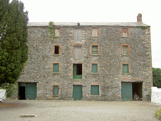
Granary in Monksland has a ramp straight to the third storey, giving a horse a fair chance of arriving upstairs before the man in charge. “How did you get up here?” “Promotion. Where’s the hay?”
Detached five-bay four-storey former granary, built c. 1810. Rectangular-plan, gable-fronted extension to east, ramp to north gable third-storey with squared coursed rubble plinth walling, rendered segmental coping. Pitched slate roof, clay ridge tiles, stone verge coping, red brick bellcotes to gables, remains of winch to west elevation, red brick corbel eaves course. Coursed rubble walling, roughly squared sandstone quoins. Square-headed window openings, red brick block-and-start surrounds, relieving arches, timber lintels, stone sills, some timber sheeted shutters in-situ. Square-headed door openings, red brick block-and-start surround, painted timber sheeted door to north, square-headed door and loading bays to west, timber lintels, redbrick relieving arches, painted timber sheeted doors. Set back from main road within grounds of ruined mill complex now used as pasture land.
This former grain store retains some interesting features such as the gabled mounted bellcotes and ramped access to the north which add to its appeal. The location of this building within a large complex of ruined mill buildings suggests the presence of a once thriving industrial community in this area. The building stands a reminder of the industrial heritage of the area.
From the Buildings of Ireland (National Inventory of Architectural Heritage) record 13900813
This does not grant access. Most recorded buildings are privately owned; view them only from public ground unless the owner allows entry.
Places near here
Photo credits
- Eric Jones, Geograph · CC BY-SA 2.0
- Eric Jones, Geograph · Creative Commons Attribution-ShareAlike 2.0
- Oliver Dixon, Geograph · CC BY-SA 2.0
 Saint James's Catholic ChurchChurch/chapel · 81 yd
 Grange Abbey (in Ruins)Church · 105 yd
 The BushPicnic place · 1576 yd
 Grange UpperMountain / peak · 1.1 mi
 Ballug CastleCastle, tower house · 1.4 mi
 Ballug CastleCastle · 1.4 mi
 St James WellSpring · 1.6 mi
 BarnavaveMountain / peak · 1.7 mi
 Lady WellHoly well · 1.8 mi
 Cooley PointHeadland · 2.5 mi
 GreenoreVisitor information · 2.5 mi
 Greenore PointHeadland · 2.7 mi
More historic places in County Louth · All of County Louth
What do you know about this place?