
What is recorded here
From the National Monuments Service (Archaeological Survey of Ireland) record CO066-014
Places near here
Photo credits
- Maker not stated on source page, www.youtube.com
- Maker not stated on source page, www.tripadvisor.com
- National Inventory of Architectural Heritage
- Maker not stated on source page, www.alamy.com
- Maker not stated on source page, www.pinterest.com
- Maker not stated on source page, it.pinterest.com
- Maker not stated on source page, www.geograph.ie
- Mike Searle, Geograph · Creative Commons Attribution-ShareAlike 2.0
- Antiqueight, Wikimedia Commons · CC BY-SA 4.0
- Kmcnamee, Wikimedia Commons · CC BY-SA 4.0
 Enclosure in Ballygibbon (imokilly By.)Enclosure · 1128 yd
Explorer Tom Enclosure in Ballygibbon hears everything through its walls, including the cows complaining about the grass quality…
 Fairy fort / earthen ringfort in RathcanningFairy fort / earthen ringfort · 1132 yd
Explorer Tom Fairy fort / earthen ringfort in Rathcanning would tell you after three pints that it was actually built by aliens. It…
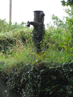 water pump1260 yd
Explorer Tom Kilcounty’s water pump has more curves than my gym instructor and it’s proud of it. It used to be the village gossip…
 Ogham Stone1460 yd
Explorer Tom Ogham Stone in Glenaphuca used to be a door jamb for a cart house. It’s got a broken top and an inscription that reads…
 Church (in Ruins)Church · 1675 yd
Explorer Tom Church in Kilcounty has low overgrown walls and a gap near the west end that was probably a doorway. It contains three…
 Fairy fort / earthen ringfort in Castletown (imokilly By.)Fairy fort / earthen ringfort · 1.1 mi
Explorer Tom Castletown in County Cork has vanished into thin air. The 1842 map showed a circular enclosure, but now it's just…
 Fairy fort / earthen ringfort in DonickmoreFairy fort / earthen ringfort · 1.1 mi
Explorer Tom Fairy fort / earthen ringfort in Donickmore has got two banks and a ditch, plus a causeway for easy entry. It sits…
 GlengarraCountry house · 1.4 mi
Explorer Tom Glengarra in Kilcounty is a former country house from around 1810 with an ionic portico on the front. It’s been sitting…
 Dangan BridgeBridge · 1.5 mi
Explorer Tom Dangan Bridge in Ballyre has round arches built with skilled craftsmanship using local stone. There’s a feud with the…
 SpringfieldCountry house · 1.7 mi
Explorer Tom Springfield in Killeennamanagh is a big, vacant U-plan country house from 1770 with imposing chimneys. It’s got that…
 Clonmult Ambush SiteBattlefield · 1.8 mi
Explorer Tom Clonmult Ambush Site in County Cork is basically a dating profile that says 'likes surprise attacks and running away,'…
 Jamesy Kelleher Memorial Park, DungourneyGAA ground · 1.8 mi
More archaeology and monuments in County Cork · All of County Cork

What do you know about this place?Tap to add a comment or ask a question