
Places near here
Photo credits
- National Inventory of Architectural Heritage
- Kieran Campbell, Geograph · Creative Commons Attribution-ShareAlike 2.0
- Vadim Manuylov, Wikimedia Commons · CC BY-SA 3.0
- Mike Searle, Geograph · CC BY-SA 2.0
- Kieran Campbell, Wikimedia Commons · CC BY-SA 2.0
- Malene Thyssen, Wikimedia Commons · CC BY-SA 3.0
 Glebe HouseRectory/glebe/vicarage/curate's house · 122 yd
Explorer Tom Glebe House was built by someone who really wanted symmetry to do all the heavy lifting without any fuss. The builder was probably thinking, 'Let's make this round window really pop against the walls.' Perfect spot to practice your polite nodding at passersby.
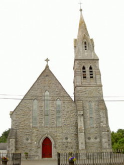 Saint Nicholas's Catholic ChurchChurch/chapel · 535 yd
Explorer Tom Saint Nicholas's Catholic Church has seagulls that constantly complain about the stonework being too shiny for their taste. W.H. Byrne designed it to look like a very serious rock in the countryside. Leave nothing but footprints and your sense of awe.
 Graveyard in Richardstown (ardee By., Richardstown Par.)Graveyard · 1548 yd
Explorer Tom Richardstown’s graveyard sits in the wooded grounds of a castle with a modern top half. It is secretly proud of the potato it grew there in 1740. Dare you to say hello to it out loud.
 Monterey Cypress1602 yd
Explorer Tom Monterey Cypress in County Louth does weird yoga poses when nobody's looking, twisting its branches into shapes that defy physics. Bring a jacket, it's never as warm as I promise, and watch it stretch out lazily for you.
 Richardstown CastleCastle, tower house · 1615 yd
Explorer Tom Richardstown Castle has four round towers that make it look like it’s trying to hold up the sky. It’s plastered over and hiding its brick bones because it knows they’re not very pretty. Bring a camera and your most suspicious face.
 CastleCastle, motte · 1.6 mi
Explorer Tom Castle at Dromin is a massive dirt pile that refuses to let go of one stubborn pigeon who thinks he owns it. The birds are staging a permanent protest up there. Grand place for a sulk or a snog, your call.
 IndicatedGraveyard · 1.6 mi
Explorer Tom Graveyard in Dromin was built on a bargain where St Finian promised good weather if they dug deep enough. The church remains are right there, looking tired and medieval. Linger, it's not going anywhere and neither should you.
 Graveyard in StickillinGraveyard · 2.3 mi
Explorer Tom Stickillin’s medieval church had stained glass found during conservation work, which is fancy for ruins. If it had to teach history, it would use flashcards and bad puns. Great spot to propose. Or at least to propose lunch.
 Greenmount MotteArchaeological place · 2.7 miDrummeenagh HillMountain / peak · 3.4 mi
 European Beech3.7 mi
Explorer Tom European Beech in County Louth has a poet who fell in the ditch nearby, crying about his socks getting muddy. Have a sandwich here and call it a heritage lunch while you watch him mutter verses at your feet.
Tullydonnell HillMountain / peak · 4.6 miMore archaeology and monuments in County Louth · All of County Louth

What do you know about this place?Tap to add a comment or ask a question