
Places near here
Photo credits
- National Inventory of Architectural Heritage
- Mike Searle, Wikimedia Commons · CC BY-SA 2.0
- Garry Dickinson, Wikimedia Commons · CC BY-SA 2.0
- No machine-readable author provided. Christian1965~commonswiki assumed (based on copyright claims)., Wikimedia Commons · Public domain
- Jon Sullivan, Wikimedia Commons · Public domain
- Joseph Mischyshyn, Geograph · Creative Commons Attribution-ShareAlike 2.0
- Miguel Angel Masegosa Martínez, Wikimedia Commons · CC BY 2.0
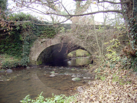 Roxborough BridgeBridge · 397 yd
Explorer Tom Roxborough Bridge would be the uncle at the wedding who stands in the doorway talking about masonry. It’s got limestone rubble mixed with fancy ashlar, which is weirdly cool. Whisper to it if you dare.
 Ballyclogh HouseHouse · 600 yd
Explorer Tom Ballyclogh House in Limerick has been standing since the mid-seventeenth century, which is basically forever in house terms. The bishop who refused to visit probably just couldn't get past the gates. Bring your own legend, I'll supply the wine.
 Lickadoon CastleCountry house · 1.2 mi
Explorer Tom Lickadoon Castle’s first owner had an escape plan involving a rope and a very confused horse. It didn’t work, but he’s still proud of the idea. Ten minutes here and you’ll understand why he wanted out so badly.
 Friarstown HouseCountry house · 1.5 mi
Explorer Tom Friarstown House in County Limerick is such a show-off with its £10,000 price tag and all that fancy fanlight nonsense. It probably reviews every visitor who passes by, giving you two stars for not bringing enough flowers to admire its timber sashes. You don’t need to enter to know it’s judging your outfit, so just smile politely from the road.
_-_geograph.org.uk_-_4570282.jpg/250px-Castles_of_Munster,_Rathurd,_Limerick_(3)_-_geograph.org.uk_-_4570282.jpg "Photo: Mike Searle, Wikimedia Commons · CC BY-SA 2.0") Castle (in ruins)Castle, tower house · 1.5 mi
Castle (in ruins)Castle, tower house · 1.5 miExplorer Tom Castle in Rathurd is having a rivalry with a more famous place down the road, but it’s too busy being a house to care. The circular shape is just its way of saying 'go around me.' Find a local and ask them the real story, then come back and tell me.
 Lickadoon Castle (in ruins)Castle, tower house · 1.5 mi
Explorer Tom Lickadoon Castle handles nosey neighbours by staying square and silent, refusing to let anyone peek inside its spiral stair secrets. It just stands there judging your posture from a distance, so stand still and listen, because the wind tells its story better than I ever could.
 presbytery/parochial/curate's house1.7 mi
Explorer Tom Presbytery in Bohereen has an imaginary fan club of ghosts who love its render adornment and red brick chimneystacks. It's been a parochial house for so long it forgot how to be normal. It's free, it's odd, what more do you need?
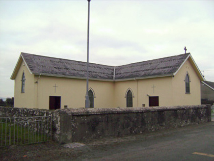 Saint Patrick's Catholic ChurchChurch/chapel · 1.8 mi
Explorer Tom Saint Patrick’s Catholic Church in Bohereen started because two lads made a drunken bet in the local pub. It built this modest church to prove they weren’t just talking rubbish, and they succeeded. Stand still and listen to its quiet confidence.
 Áine and Gearóid Iarla: Lough GurLegend location · 7.7 mi
Explorer Tom Áine and Gearóid Iarla: Lough Gur has a goddess for the lake and a sleeping lord in the old stories. I thought I was coming to admire water and stones. Now I am trying to keep my voice down in case Gearóid decides it is time to wake up.
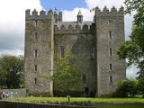 Bunratty CastleCastle · 9.7 mi
Explorer Tom Bunratty looks ready to argue with anyone coming up the river. Bunratty Castle stands where the Ratty River meets the Shannon, which is exactly what its Irish name tells you if you ask it politely. The tower you see is a 15th century MacNamara job, but this site had already chewed through several earlier castles. Richard de Clare's stone stronghold met a particularly brisk end in 1318: after he died at Dysert O'Dea, Lady de Clare burned castle and town before fleeing to Limerick. You can imagine the neighbours deciding not to ask how her day went. I'd have asked the lord for a room, then remembered I prefer doors I can open myself. The present tower survived to become one of Clare's most recognisable sights, with rooms that make the scale of a medieval household much easier to grasp than any tidy date on a plaque. The castle and folk park are managed visitor attractions, so check current admission and opening hours before setting out. Go for the stonework, stay long enough to hear the river making its own quiet argument about who really owns the place.
 Graveyard9.9 mi
Explorer Tom Graveyard in Bunratty West is hanging out right behind the castle hotel, which feels like standing in someone's kitchen. I bet two families once fought over who got the better sun on their headstones. Look up, because the best gossip is always above your eye level.
 Sweet Chestnut10 mi
Explorer Tom Sweet Chestnut in County Clare was planted by a builder who was really thinking about how many sandwiches he could eat under its shade during lunch breaks. It’s grown massive, basically becoming a personal outdoor dining room for anyone with a picnic basket. Ideal for a moody photo you'll pretend wasn't posed.
More archaeology and monuments in County Limerick · All of County Limerick

What do you know about this place?Tap to add a comment or ask a question