
What is recorded here
From the National Monuments Service (Archaeological Survey of Ireland) record LE029-011
Places near here
Photo credits
- National Inventory of Architectural Heritage
- Oliver Dixon, Geograph · Creative Commons Attribution-ShareAlike 2.0
- Fifiheavey, Wikimedia Commons · CC BY-SA 4.0
- Sitomon, Wikimedia Commons · CC BY-SA 2.0
- Maker named on the Wikimedia Commons picture page · CC BY-SA 2.5
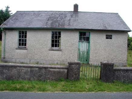 Gortachoosh National SchoolSchool · 1.9 mi
Explorer Tom Gortachoosh National School is a former school that probably saw a poet fall in the ditch next door. The slate roof and sash windows are original, which is rare these days. Get a photo with it before it rots away.
 Saint Columba's Church (Drumreilly)Church/chapel · 2.0 mi
Explorer Tom Saint Columba's Church in Drumreilly would teach history by pointing at its own stonework and saying 'look how fancy this is.' It’s got cast-iron gates that look like they’re guarding a secret party. Stand there long enough and you’ll feel properly educated about arches.
 IndicatedGraveyard · 2.5 mi
Explorer Tom Graveyard in Ardunsaghan means 'High Place of the Ghosts' or something equally terrifying, I think. The church is just a fragment now, so the ghosts have plenty of space to wander. Give it a pat on the way past, it's had a long life.
Swan Island pet farmHeritage attraction · 3.6 miKing's GraveArchaeological place · 4.0 mi Graveyard4.1 mi
 European Yew4.2 mi
Explorer Tom European Yew has a bird that refuses to leave because it’s the only thing keeping it company. It’s an ancient tree that looks like it’s holding up the sky with one arm. Go in good boots and better humour.
Crane IslandIslet · 4.2 miBatteryBawn · 4.2 mi Sessile Oak4.3 mi
Explorer Tom Sessile Oak in County Leitrim remembers when a local priest lost a bet right under its branches. He owed a pint and swore he’d never come back, but the tree saw him every time. Dare you to say hello to it out loud.
DrummuckerMountain / peak · 4.3 miGiant's GraveArchaeological place · 4.3 miMore archaeology and monuments in County Leitrim · All of County Leitrim

What do you know about this place?Tap to add a comment or ask a question