
What is recorded here
From the National Monuments Service (Archaeological Survey of Ireland) record WA006-021
Places near here
Photo credits
- Maker not stated on source page, ca.pinterest.com
- Maker not stated on source page, www.pinterest.com
- National Inventory of Architectural Heritage
- Maker not stated on source page, au.pinterest.com
 Stone row in Tooreen EastStone row · 1102 yd
Explorer Tom Stone row in Tooreen East is a mini army that never got the memo about standing up straight. Three little stones…
 Standing stone in Reanadampaun Commons (decies Without Drum By.)Standing stone · 1377 yd
Explorer Tom Standing stone in Reanadampaun Commons in County Waterford has a damaged top that looks like it lost a fight with the…
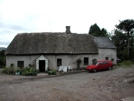 Shanballyanne CottageHouse · 1.1 mi
Explorer Tom Shanballyanne Cottage is made of mud and thatch, which means the wind treats it like a personal rival every single day.…
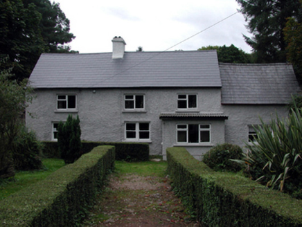 farm house1.6 mi
Explorer Tom Farm house in Shanballyanne is posing as a country gent while secretly running on fumes and over-zealous renovations…
 Standing stone in CastlereaghStanding stone · 1.8 mi
Explorer Tom Standing stone in Castlereagh is a rectangular conglomerate block involved in a bitter feud with the next village over…
 Labartt's BridgeBridge · 1.9 mi
Explorer Tom Labartt’s Bridge in Glennanore spans the River Nier with such elegant grace that I bet it hums a lullaby to the fish at…
 Historic buildingOfficially recorded historic building · 1.9 mi
Explorer Tom Historic building in Glennanore is a post box that thinks the mailman owes it money. It’s got a royal cipher on it…
 Glennanore National SchoolSchool · 1.9 mi
Explorer Tom Glennanore National School keeps whispering to its younger self that being made of mixed-colour sandstone was actually…
 Catholic Church of Saint Helena of the CrossOfficially recorded historic building · 1.9 mi
Explorer Tom Catholic Church of Saint Helena of the Cross in Glennanore is where the map makers completely lost their minds. They…
 Nire Church GraveyardGraveyard · 1.9 mi
Explorer Tom Nire Church Graveyard in County Waterford has a long-standing grudge with the weather, who seems to pick on it…
 Knockalisheen BridgeOfficially recorded historic building · 1.9 mi
Explorer Tom Knockalisheen Bridge has a bad poem written about it by a local lad who thought 'spanning' was a verb for dancing. It’s…
 outbuilding2.0 mi
Explorer Tom Outbuilding in Graignagower is a disused shed that refuses to die, standing proudly on the road with all its original…
More archaeology and monuments in County Waterford · All of County Waterford

What do you know about this place?Tap to add a comment or ask a question