Places near here
Photo credits
- National Inventory of Architectural Heritage
- Mike Searle, Geograph · CC BY-SA 2.0
- Rigger30, Wikimedia Commons · Public domain
- Paddy Ryan, Wikimedia Commons · CC BY-SA 4.0
Explorer Tom Ladys Well in Coogulla had a bishop who refused to visit because he thought the lighting was terrible. It’s partially collapsed now, which only adds to its dramatic, tragic beauty in our eyes. Best visited with a curious kid and no timetable.
IndicatedFairy fort / earthen ringfort · 1693 ydExplorer Tom Fairy fort or earthen ringfort in Penane was recently overthrown by a fox who decided he had better leadership skills than whatever spirit used to live there. The whole place is so overgrown now that it’s basically a bush with a secret agenda and zero manners. Bring a flask of something warm and a story to swap.
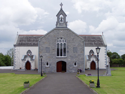 Catholic Church of Saint John the BaptistChurch/chapel · 1.2 mi
Explorer Tom This Catholic Church of Saint John the Baptist can hear the neighbours arguing through its thick walls, but it pretends to be busy admiring its own ornate reredos instead. It’s got a gable front that stands on the road like a bouncer who knows everyone’s name and sins. Tell me you’ve seen a more dramatic church entrance.
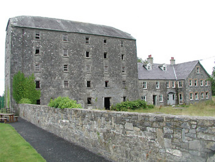 mill (water)1.5 mi
Explorer Tom Mill in Graiguefrahane was built by someone who thought ‘imposing’ meant ‘look at me while I grind flour’. It’s standing near a pre-1700 site, acting like it invented the concept of regular windows. The builder probably spent hours staring at the manager's house, wondering why his mill wasn’t getting enough attention from the local cows.
 Castle (in Ruins)Bawn · 1.6 mi
Explorer Tom Castle in Castleleiny ended up in the wrong place because the map was drawn by someone who really hated geometry class. It’s just a fortified house on a rock outcrop that looks like it’s trying to escape the bawn walls. Ideal spot for a dramatic phone call.
 Loughmoe CourtHouse, fortified house · 1.6 mi
Explorer Tom Loughmoe Court in Tinvoher was once ruled by a goat, or so the stones claim. It’s all gone now, but the drama lingers in the air like cheap cologne. Whisper a secret at it, it's kept worse.
 barracks1.6 mi
Explorer Tom Barracks in Tinvoher is still upset that a bishop refused to visit because he didn’t like the view from the windows. It’s got those decorative render quoins and sash windows, acting like it’s still on duty for the RIC. Give it a nod if you pass by, but keep your distance; it’s currently throwing a tantrum about its village building status.
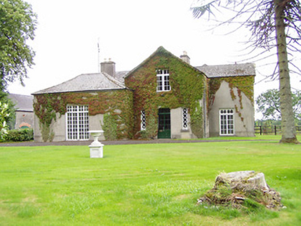 Bellwood HouseHouse · 1.7 mi
Explorer Tom Bellwood House in Greenwood is stuck in a feud over who owns the view. Its outbuildings are a splash of red brick and purple slate that adds serious textural interest to Templemore. Never copy the neighbours' shade.
Morris's GroveForest · 2.9 miExplorer Tom Morris's Grove in County Tipperary has a retirement plan that involves turning into a very expensive bench for rich tourists who need to look important. It’s basically saving up its leaves for the pension fund right now. Ideal for a moody photo you'll pretend wasn't posed.
Tullow HillMountain / peak · 4.1 miExplorer Tom Tullow Hill thinks the map makers got its name wrong on purpose just to mess with its head, which is why it looks so grumpy today. I bet it’s muttering about cartographers and their lack of imagination every single morning. Go back in winter, it's a different animal.
Kilvilcorris BogForest · 4.7 miExplorer Tom Kilvilcorris Bog in County Tipperary had a fox take charge of the whole operation for about three weeks, and honestly, it ran things better than the humans did. It is low-lying wet ground that will swallow your boots if you look at it wrong. Tell the next person you meet it's haunted. It might be.
 Devil's Bit MountainMountain / peak · 6.2 mi
Explorer Tom Devil's Bit Mountain is where some poor sod’s love story went completely pear-shaped next to the cliff edge. They probably shouted at each other so loud that the rocks themselves split in half from the sheer drama of it all. Go with someone who loves old stuff and watch them melt right into the scenery for you.
More historic places in County Tipperary · All of County Tipperary

What do you know about this place?Tap to add a comment or ask a question