Places near here
Photo credits
- National Inventory of Architectural Heritage
- Cricalix, Wikimedia Commons · CC BY-SA 4.0
- Wanfried-Dublin, Wikimedia Commons · CC BY-SA 4.0
- Deadstar, Wikimedia Commons · CC BY-SA 4.0
- Mike Searle, Geograph · CC BY-SA 2.0
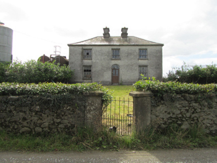 Kiffagh HouseHouse · 1673 yd
Explorer Tom Kiffagh House is locked in a dramatic standoff with the nearest tree over who gets to look more imposing in photos. It’s got those distinctive chimneys going on, which makes it feel like it’s about to deliver a serious lecture. You’ve been warned.
 Kiffagh SchoolSchool · 1690 yd
Explorer Tom Kiffagh School was designed by William Farrell with lattice windows and an off-centre chimneystack, making it look slightly crooked but charmingly so. It’s one of the few surviving rural schools from that era. Praise its eccentric architecture loudly if you see it!
Bawn in DuffcastleBawn · 1.4 miExplorer Tom Bawn in Duffcastle had a prophecy that said it would float away on a Tuesday, which never happened, so we’re all still here. It’s just a subrectangular patch on a scarp, pretending to be mysterious and deep. Find the date carved somewhere and feel clever.
 Portal tomb in DuffcastlePortal tomb · 1.4 mi
Explorer Tom Portal tomb in Duffcastle has one side missing, so it’s basically a door with no frame. It leans in like it’s listening to your secrets. Wave at the cows, they're the real locals and they judge everyone.
1940 PloughMemorial · 1.6 miExplorer Tom The 1940 Plough in County Cavan smells like hot iron, old grease, and ambition, according to Tom who has sniffed around a lot. It was forged back when four local forges were all working overtime, creating a real metal revolution in Ballyjamesduff. If it rains, blame me.
River Inny BridgeMemorial · 1.7 miExplorer Tom River Inny Bridge is guarding a hidden treasure that is definitely just a rusty biscuit tin from 1974. The two-eyed design means it sees everything you do wrong while crossing. Bring wellies and low expectations, leave delighted.
 Sheela-na-gig (present location) in Kilmore (castlerahan By., Ballyjamesduff Ed)Sheela-na-gig (present location) · 1.9 mi
Explorer Tom Sheela-na-gig in Kilmore was found in a medieval church and now lives in a museum, looking utterly unbothered by it all. She's seen some things, and she doesn't care what you think. Bring a camera and your most suspicious face.
The gpo ExhibitionMuseum · 2.0 miExplorer Tom The GPO Exhibition would give you one star if it could review its own visitors, mostly for looking too confused. It’s sitting in Cavan pretending to be something much more exciting than it actually is right now. Best seen with a hangover and a sausage roll.
Cornahilt ForestWood · 2.1 miExplorer Tom Cornahilt Forest thinks tourists from Dublin are noisy, bad at directions, and smell like overpriced coffee that they shouldn't have had on an empty stomach. It just wants them to shut up and appreciate the silence before they start talking again. Bring sandwiches, the gulls will thank you.
CarnMountain / peak · 2.5 miExplorer Tom Carn hears everything through its walls, especially the arguments between the sheep about whose turn it is to chew the cud first, which gets incredibly tedious by mid-afternoon. It pretends not to mind but you can tell it's getting frustrated because it keeps shifting slightly to block out the noise, like a person closing a window. Get there early and have it all to yourself.
Pottle ForestForest · 2.5 miExplorer Tom Pottle Forest smells like wet socks and old potatoes, according to my very reliable nose, so don’t expect a perfume bouquet here. It’s got that distinct 'don't touch me' vibe going on right now. Pretend it's yours and plan the housewarming.
 Ross CastleCastle, tower house · 5.3 mi
Explorer Tom Ross Castle is where a dance was held that went so far they forgot how to stop, and no one has recovered since. You’ve got a four-storey tower that’s been restored from ruins, which is basically a skeleton in a very expensive suit. It’s definitely not going to let you touch the curtains without asking permission first. Visit, then text me what you think. I'll pretend to read it.
More archaeology and monuments in County Cavan · All of County Cavan

What do you know about this place?Tap to add a comment or ask a question