What is recorded here
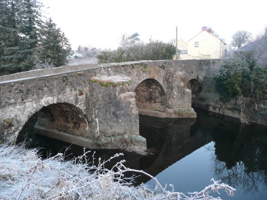
This bridge gives its name to the town of Ballindrait (Baile an Droicheaid - the town or place of the bridge), and there may have been a bridge here by the early 17th century at the latest. The village probably dates from the Plantation-era. A bridge is depicted here on Moll’s map of Ireland (1714) while the town is indicated as Ballindrait; this suggests that this was the site of a bridge for a period by this date. The current triple-arched structure with V-profile cutwaters probably dates to the first half of the 18th century and it is possible that it might contain within it elements of earlier fabric (pers. comm. T.J. O'Meara).
The attached image is uploaded courtesy of the National Inventory of Architectural Heritage.
Compiled by: Paul Walsh
Date of upload: 07 November 2013
The monument record does not grant public access. Check the route and ask the landowner before entering private land.
- What survives
- Recorded monument
Places near here
 Ballindrait Bridgebridge · 1 yd
 Ballindrait Presbyterian Churchchurch/chapel · 154 yd
 Enclosure in Shannon LowerEnclosure · 1673 yd
 Enclosure in GlensmoilEnclosure · 1.4 mi
 Croaghan HillMountain / peak · 1.5 mi
 BATTLE SITE: BATTLE OF THE FORDS, Central crossing, 1689 in Magirr; Town Parks OF StrabaneBATTLE SITE: BATTLE OF THE FORDS, Central crossing, 1689 · 2.1 mi
 Feddyglass WoodWood · 2.4 mi
 Second World War MemorialMemorial · 2.7 mi
 Abercorn FactoryHeritage attraction · 2.7 mi
 CASTLE in Town Parks OF StrabaneCASTLE · 2.8 mi
 Gray PrinterHeritage attraction · 2.9 mi
 1916 Easter Rising Memorial StoneMemorial · 2.9 mi