
What is recorded here
From the National Monuments Service (Archaeological Survey of Ireland) record KD019-008009
Places near here
Picture notes
- Computer-made picture. It does not show this monument.
- Darrin Antrobus, Wikimedia Commons · CC BY-SA 2.0
- jwd, Geograph · CC BY-SA 2.0
- Computer-made picture. It does not show this mountain top.
- Alvesgaspar, Wikimedia Commons · CC BY-SA 3.0
- Computer-made picture. It does not show this playground.
- Sitomon, Wikimedia Commons · CC BY-SA 2.0
- Computer-made picture. It does not show this garden.
- Mike Searle, Geograph · CC BY-SA 2.0
- JP, Geograph · CC BY-SA 2.0
 OutlinedGraveyard · 1 ydComputer-made picture
Explorer Tom Graveyard in Kill West would tell a teenager the 1800s were just everyone dying with better fashion. The stone wall is doing all the heavy lifting here, honestly. It's the kind of place that makes a dull Tuesday interesting.
 Saint John's Church (Kill)Church/chapel · 22 yd
 Ecclesiastical enclosure in Kill WestEcclesiastical enclosure · 24 ydComputer-made picture
Explorer Tom Ecclesiastical enclosure in Kill West hums a low, monastic drone at midnight to scare off the tourists. It sits near an old church, probably judging your prayer form from below. Give it a pat on the way past, it's had a long life.
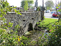 bridge139 yd
Explorer Tom Bridge in Kill East spans the stream with such confidence it probably thinks it’s a toll booth. If zombies attack, it just stands there while they trip over themselves. If it’s closed, admire the stonework from afar.
 Kill HillMountain / peak · 1049 ydComputer-made picture
 Black HillMountain / peak · 1.3 miComputer-made picture
 Common Lime1.3 mi
 Children's playground1.7 miComputer-made picture
 European Yew1.7 mi
 Hunting BrookGarden · 4.7 miComputer-made picture
 CastleCastle, tower house · 4.9 mi
Explorer Tom Castle in Newcastle North is a flat-topped mound that looks like a giant’s pillow left out in the rain. It’s been sitting there since 1200, judging the church next door without saying a word. Snap one photo, then put the phone away and actually look.
 Grand Canal WayWalking route · 6.2 mi
Explorer Tom Grand Canal Way in County Dublin is pretending to be Kildare according to one cheeky map note. A little county peninsula poking through like a nosy neighbour. Tell me if it's still hiding!
More archaeology and monuments in County Kildare · All of County Kildare

What do you know about this place?Tap to add a comment or ask a question