
What is recorded here
From the National Monuments Service (Archaeological Survey of Ireland) record KD019-008005
Places near here
Photo credits
- Darrin Antrobus, Wikimedia Commons · CC BY-SA 2.0
- National Inventory of Architectural Heritage
- Alvesgaspar, Wikimedia Commons · CC BY-SA 3.0
- Sitomon, Wikimedia Commons · CC BY-SA 2.0
- Bogman, Wikimedia Commons · CC BY-SA 3.0
- Mega Phil, Wikimedia Commons · CC BY-SA 4.0
- Ian Paterson, Geograph · CC BY-SA 2.0
- Colin Park, Geograph · CC BY-SA 2.0
- Ridiculopathy, Wikimedia Commons · CC0
- Ian Paterson, Wikimedia Commons · CC BY-SA 2.0
- JP, Geograph · CC BY-SA 2.0
- Robert Bone, Geograph · CC BY-SA 2.0
 Saint John's Church (Kill)Church/chapel · 19 yd
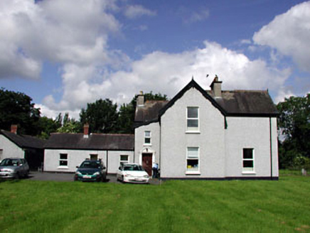 Marsville HouseHouse · 112 yd
Explorer Tom Marsville House in Kill West is showing off its weird roofline like it invented asymmetry. It’s got more gables than a confused architect’s nightmare, and honestly? I respect the chaos. Spot that oldest stone and give it a wink before you waltz away!
 Common Lime1.3 mi
 European Yew1.7 mi
 Kilteel CastleCastle, tower house · 2.8 mi
Explorer Tom Kilteel Castle was guarded by Knights Hospitallers who probably spent all night playing fiddle tunes that drove the neighbors mad. It sits on a terrace watching the stream go by, judging your life choices. Have a chat with it, nobody's watching.
 Punchestown LongstoneArchaeological place · 4.2 mi
 Reeves CastleCastle · 4.2 mi
 Cupidstown HillMountain / peak · 4.2 mi
 Brides WellHoly well · 4.7 mi
 Rathcoole ParkPark · 5.9 mi
Explorer Tom Rathcoole Park in County Dublin has trees that remember every secret whispered beneath them. The wind carries old gossip today. Lean against a trunk and listen for the juicy details from centuries past.
 Grand Canal WayWalking route · 6.2 mi
Explorer Tom Grand Canal Way in County Dublin is pretending to be Kildare according to one cheeky map note. A little county peninsula poking through like a nosy neighbour. Tell me if it's still hiding!
 Sorrel HillMountain / peak · 9.2 mi
More archaeology and monuments in County Kildare · All of County Kildare

What do you know about this place?Tap to add a comment or ask a question