
What is recorded here
From the National Monuments Service (Archaeological Survey of Ireland) record LH010-002
Places near here
Photo credits
- Kieran Campbell, Geograph · CC BY-SA 2.0
- Maker not stated on source page, en.wikipedia.org
- Maker not stated on source page, www.pinterest.com
- Maker not stated on source page, commons.wikimedia.org
- National Inventory of Architectural Heritage
- Fintan McTiernan; published by Monaghan GAA, www.flickr.com
- Maker not stated on source page, www.gettyimages.in
 mill (water)487 yd
Explorer Tom The Mill in Killanny is powered by nothing but pure 19th-century stubbornness. Some hero saved it from becoming a car…
 Church (in ruins)Church · 523 yd
Explorer Tom Church in Killanny has a superstition that if you touch the east gable, you’ll never be late again. Locals swear by it…
 Killanny Old GraveyardGraveyard · 525 yd
Explorer Tom Killanny Old Graveyard in County Louth hosted a dance once that went way too far, and now the ground still feels…
 Mapped cemeteryCemetery · 791 yd
Explorer Tom Mapped cemetery in County Louth has a ghost who is far too lazy to haunt it properly, preferring to nap in the shadows…
 New BridgeBridge · 1200 yd
Explorer Tom New Bridge’s least favourite visitor is probably a tourist who keeps asking if it’s new, because it clearly isn’t. It…
 Páirc Eanna, Killanny GeraldinesGAA ground · 1209 yd
 Catholic ChapelChurch · 1301 yd
Explorer Tom Catholic Chapel in Corcreeghagh is haunted by a poet who fell into a ditch nearby and never recovered his dignity. It’s…
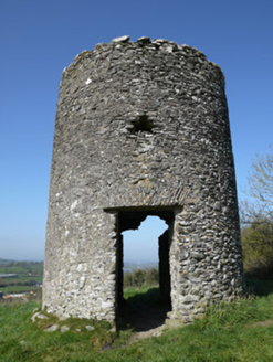 mill (wind)1457 yd
Explorer Tom Mill in Aghafad is a mid-eighteenth-century windmill that proves this area had more wheat than water power, which is…
 Ballymackney Church (Killanny)Church/chapel · 1.0 mi
Explorer Tom Ballymackney Church (Killanny) is proud of its bell-cote silhouette, which basically makes it look like it’s wearing a…
 Páirc Annaghminnon, Annaghminnon Rovers GAAGAA ground · 1.7 mi
 Fairy fort / earthen ringfort in DuneltyFairy fort / earthen ringfort · 1.8 mi
Explorer Tom Fairy fort / earthen ringfort in Dunelty is officially gone but still makes a weird rumbling sound at night when the…
 Fairy fort / earthen ringfort in Corkeeran (farney By.)Fairy fort / earthen ringfort · 2.2 mi
Explorer Tom Corduff fort is sitting on top of a hill, looking like it’s waiting for a parade that never quite showed up. It’s got a…
More archaeology and monuments in County Louth · All of County Louth

What do you know about this place?Tap to add a comment or ask a question