
What is recorded here
From the National Monuments Service (Archaeological Survey of Ireland) record ME030-027
Places near here
Photo credits
- Maker not stated on source page, www.irishamericanmom.com
- Maker not stated on source page, www.alamy.com
- Maker not stated on source page, ru.pinterest.com
- Maker not stated on source page, en.wikipedia.org
- Maker not stated on source page, www.ireland.com
- Dunderry GAA Club (individual photographer not stated), www.dunderrygaa.com
- Maker not stated on source page, www.dreamstime.com
- Kieran Campbell, Geograph · CC BY-SA 2.0
- National Inventory of Architectural Heritage
- Maker not stated on source page, www.pinterest.com
 Fairy fort / earthen ringfort in ArdgreaghFairy fort / earthen ringfort · 805 yd
Explorer Tom Fairy fort / earthen ringfort in Ardgreagh is having a quiet drama with the nearest tree about who looks more…
 Memorial stone in IskaroonMemorial stone · 1339 yd
Explorer Tom Memorial stone in Iskaroon was once run by a matchmaker who thought every couple needed a stone to argue about for…
 Holy well in IskaroonHoly well · 1361 yd
Explorer Tom Holy well in Iskaroon was once ruled by a goat that ate all the signage. Now it’s just a drain with big dreams and no…
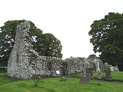 Church (Site of)Church · 1.4 mi
Explorer Tom Church in Kiltoome is on fairly level ground and has been confused with a church in Westmeath for so long that the…
 Ecclesiastical enclosure in Kilcooly (navan Upper By.)Ecclesiastical enclosure · 1.6 mi
Explorer Tom Ecclesiastical enclosure in Kilcooly thinks Dublin tourists are just very confused sheep. It surrounds the church with…
 Dunderry GAAGAA ground · 1.6 mi
 Mapped cemeteryCemetery · 1.7 mi
Explorer Tom Mapped Cemetery claims it’s been standing here since before the concept of time was even invented by confused humans in…
 Gatehouse in MoymetGatehouse · 1.7 mi
Explorer Tom Gatehouse in Moymet has a vaulted passage that looks like it’s got a cold, and the walls are all crumbling out of sheer…
 Moymet CastleCastle, tower house · 1.8 mi
Explorer Tom Moymet Castle is where Saint Patrick would have stopped to complain about his shoes, then kept walking anyway. You’ve…
 Lackanash CottageHouse · 1.8 mi
Explorer Tom Lackanash Cottage in Lackanash, County Meath once had a cow try to buy it with a single udder. The canted bay window is…
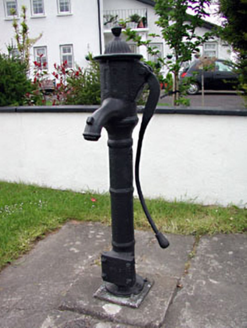 water pump1.8 mi
Explorer Tom Water pump in Newtown lost a bet with a priest over how much water it could actually dispense, and it’s been sulking…
 Dunderry CemeteryCemetery · 1.8 mi
Explorer Tom Dunderry Cemetery would describe itself to a stranger as 'a place for deep thought and occasional moss growth.' It…
More archaeology and monuments in County Meath · All of County Meath

What do you know about this place?Tap to add a comment or ask a question