DDiscover AloneMapAbout

Crosspatrick graveyard

Graveyard
Computer-made picture that does not show Crosspatrick graveyardNot a photo of this monument
Computer-made picture. It does not show this monument. · Report the wrong picture

The monument record does not grant public access. Check the route and ask the landowner before entering private land.

What do you know about this place?Tap to add a comment or ask a question

What you write will be public.

What is recorded here

Located on low N-S ridge, in an area of undulating pasture. This graveyard is named ‘Crosspatrick Grave yd.’ on the 1838 OS 6-inch map where it is shown as a roughly square enclosure (c. 30-35m max dim.) with a church (MA022-043001-) slightly to N of centre. The modern extent of the graveyard indicates that it has…

Read the whole record
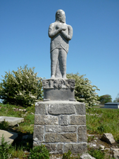
Located on low N-S ridge, in an area of undulating pasture. This graveyard is named ‘Crosspatrick Grave yd.’ on the 1838 OS 6-inch map where it is shown as a roughly square enclosure (c. 30-35m max dim.) with a church (MA022-043001-) slightly to N of centre. The modern extent of the graveyard indicates that it has been extended since that date, principally to N and S, so that it now encloses an elongated sub-rectangular area (c. 130m N–S; 40-50m E–W) with the church located slightly to S of centre. It is enclosed by a mortared stone wall of relatively recent date, bordered at S and W by roads. Access is via a wrought iron gate in the W wall, with a stile-type arrangement of stone steps set in the wall immediately to S of the gate. The graveyard utilises a low narrow ridge or elevation, which extends N–S and has a gentle slope down on the E side and a steeper slope on the W side. The oldest part of the graveyard encompasses a narrow central spine of elevated ground (c. 25m N-S; 12m E-W). This is where the ruined church is located, and where the greatest concentration of graves is to be found. The ground surface here is very uneven, there are surface clusters of loose stones, low stones protruding from the ground, and several hawthorn trees and dense clumps of overgrowth. Headstones dating to the19th century predominate in the S half of the graveyard. They are interspersed with many small, low uninscribed stone grave markers, some in N-S rows; two are unusual in form, consisting of broad, thin rectangular slabs (Wth 0.8-0.9m; T 0.06-0.08m; H 0.45-0.65m), each with a small central perforation (diam. 4-5 cm). In the SW quadrant, there is another unusual gravemarker, consisting of a stone statue, a self-portrait carved by the sculptor Thomas Mulloy, which stands on an elaborately carved plinth, dated 1880. In the N half of the graveyard 20th century headstones and grave plots predominate. There are a cross-inscribed stone (MA022-044001-), known as St. Patrick’s cross, and an inscribed stone (MAA022-044002-) 30m to SSE, and a holy well (MA022-042001-) 180m to NW. Two raths (MA022-047----; MA 022-041001-) are located nearby, 240m to E and 200m to NW respectively, and there is a ringbarrow (MA022-045----) 100m to SE. Attached images: MA022-043002-_01.JPG Graveyard viewed from W MA022-043002-_02.JPG Interior of graveyard, viewed from SW MA022-043002-_03.JPG 19th-century gravemarker MA022-043002-_04.JPG 19th-century graveslab MA022-043002-_05.JPG Perforated uninscribed gravemarker MA022-043002-_01.JPG Statue of Thomas Mulloy Compiled by: Jane O’Shaughnessy Date of upload: 7 June 2019

From the National Monuments Service (Archaeological Survey of Ireland) record MA022-043002

Places near here

Picture notes
  • National Inventory of Architectural Heritage
  • Computer-made picture. It does not show this monument.
  • Andreas F. Borchert, Wikimedia Commons · CC BY-SA 4.0
  • Computer-made picture. It does not show this playground.
  • Edward S. Siebert, Wikimedia Commons · Public domain
  • Steve Edge, Geograph · CC BY-SA 2.0

More archaeology and monuments in County Mayo · All of County Mayo

Add to this placeAdd a picture Add a detailed tip Add a story

Explore the map1,093,392 places to discover

Next place · or swipeGrave monument