Places near here
Photo credits
- National Inventory of Architectural Heritage
- Fattonyni, Wikimedia Commons · CC BY-SA 3.0
- Tim Sheerman-Chase, Wikimedia Commons · CC BY 2.0
Explorer Tom Enclosure in Killuragh is visible as a cropmark of a circular fosse. It’s part of a field system, which means it was organised farming space. The crops are telling us secrets about where the ditches used to be.
Field system in KilluraghField system · 220 ydExplorer Tom Field system in Killuragh is just aerial cropmarks pretending to be architecture. Five hectares of invisible fences and ring-ditches that only satellites can see. Toast it with a cuppa and move on to the next.
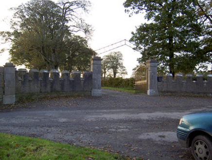 Castle KevinGates/railings/walls · 555 yd
Explorer Tom Castle Kevin in Castlekevin is telling the place that replaced it its crenellated sweep walls are much more dignified than modern fencing ever will be. It’s an imposing entrance with well-crafted copings, standing guard over the outbuildings to the north. Nod respectfully if you appreciate a wall with attitude.
 Doneraile ParkDemesne walls/gates/railings · 884 yd
Explorer Tom Doneraile Park gates are playing posh with all that cut limestone and scrollwork. They used to lead to a bridge over the river, but now they’re just standing there looking expensive next to Creagh Castle.
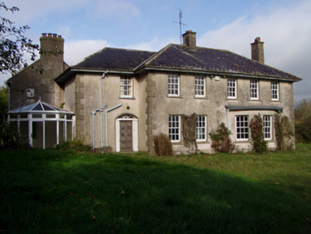 The GlenHouse · 1145 yd
Explorer Tom The Glen in Killuragh had a fire in the 1950s and added a block, so now it’s got an asymmetry that screams ‘I’m different’. The carved gate piers are elegant enough to make you feel underdressed. Great job, but don’t let the new wing steal your thunder.
 Kilcanway BridgeBridge · 1664 yd
Explorer Tom Kilcanway Bridge is straddling a dead railway line with that fancy limestone arch. Built c.1860, it’s got rock-faced voussoirs that look like they’re showing off their masonry skills. Get a close-up of the ashlar soffit for me.
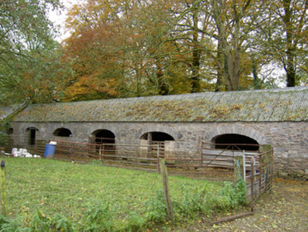 Annakisha HouseFarmyard complex · 1.0 mi
Explorer Tom Annakisha House in Annakisha South is a farmyard complex from 1847 that’s still working hard with those elliptical-arched entrances. The stone voussoirs are doing some serious flexing, and the corrugated iron roof is just adding to the charm.
Carrig Castle (in Ruins)Castle, tower house · 1.3 miExplorer Tom Carrig Castle in Carrig Demesne is basically a wall that gave up halfway. It used to be a tower, but now it's just standing there looking confused with rounded corners. I bet it's hiding a secret entrance.
 Killavullen CavesCave · 1.8 mi
Explorer Tom Killavullen Caves in County Cork are eavesdropping on every conversation near the River Blackwater right now. I swear they heard about the big sale at Tesco last Tuesday and got offended. Hang around long enough and you'll hear a story from a local.
Cave in BallymacmoyCave · 1.8 miExplorer Tom Cave in Ballymacmoy handles nosey neighbours by simply closing the door and pretending not to hear them knocking. It’s on the side of a limestone knoll, looking very smug about its privacy. Ideal stop for a big stretch and a bigger yawn after the walk.
Killavuleen loopVisitor information · 2.1 miExplorer Tom Killavuleen loop in County Cork would tell its younger self to stop walking so fast and start appreciating the fact that you’re going in circles, which is the point. It’s a path that feels like it’s trying to tell you a story but keeps forgetting the ending. Tell the next person you meet it's haunted. It might be.
 Mallow Castle RuinRuins · 4.6 mi
Explorer Tom Mallow Castle Ruin is the site of a superstition that says if you throw a pebble at it, you’ll find your lost keys. Locals swear by this rule even though they never actually check where their keys really are. Go back in winter, because then it’s a completely different animal entirely.
More caves in County Cork · All of County Cork

What do you know about this place?Tap to add a comment or ask a question