What is recorded here
From the National Monuments Service (Archaeological Survey of Ireland) record CV034-041
Places near here
Photo credits
- Oliver Dixon, Geograph · CC BY-SA 2.0
- National Inventory of Architectural Heritage
- Kevgorman, Wikimedia Commons · CC BY-SA 4.0
- Wanfried-Dublin, Wikimedia Commons · CC BY-SA 4.0
- Stephan van Helden, Wikimedia Commons · CC BY-SA 4.0
 LoughanleaghForest · 273 yd
Explorer Tom Loughanleagh has waymarked paths, so you won’t get lost, but I bet there are plenty of shortcuts for those who know where to look.
 CornasausMountain / peak · 982 yd
Explorer Tom Cornasaus is a peak in County Cavan, and I bet it keeps a close eye on Castle Saunderson from its mysterious, shadowed heights.
 post box1112 yd
Explorer Tom A rare Moyer post box from 1915 still proudly displays King George V’s cypher, even though it is painted Irish green.
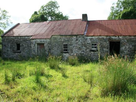 farm house1536 yd
Explorer Tom The farm house in Coppanagh has exposed rubble stone walls and a timber settle bed, standing disused with traces of its 1810 past.
CorraghyMountain / peak · 1611 ydExplorer Tom Corraghy is a peak in County Cavan, and I bet it has some ancient stone idols hiding in the bushes for you to discover today.
Castle in ruinsCastle, unclassified · 1.6 miExplorer Tom Conor O'Reilly likely erected this castle in the fifteenth century, but it was abandoned after the Plantation, leaving no convincing visible remains now.
 Fair of MuffVisitor information · 1.6 mi
Explorer Tom Check out the Fair of Muff sign, which notes a sculpture commemorating the Horse Fair held here for four centuries in County Cavan.
CastleCastle, motte · 2.8 miExplorer Tom This substantial motte at Tanderagee is encircled by a deep, waterlogged fosse, looking like a giant’s sleepy, muddy pillow.
 Grave YardGraveyard · 3.2 mi
Explorer Tom This circular graveyard in Relagh Beg features a drystone wall and headstones dating back to the early eighteenth century.
 Portal tomb in ErveyPortal tomb · 3.5 mi
 Brothers GravesVisitor information · 3.9 mi
Explorer Tom Brothers Graves holds a touching memory, marking seven Marist brothers who lived long lives in this community.
 Horse-chestnut4.2 mi
Explorer Tom A majestic Horse-chestnut in County Cavan, likely dropping glossy green cones and releasing sweet-smelling flowers that fill the air with fragrance.
More archaeology and monuments in County Cavan · All of County Cavan
What do you know about this place?Tap to add a comment or ask a question