Places near here
Photo credits
- National Inventory of Architectural Heritage
- mozzercork @ flickr, Wikimedia Commons · CC BY 2.0
- Willow, Wikimedia Commons · CC BY 2.5
- Bryan Conlon, Geograph · CC BY-SA 2.0
- Mike Searle, Wikimedia Commons · CC BY-SA 2.0
- Richard Fensome, Geograph · CC BY-SA 2.0
- Pam Brophy, Wikimedia Commons · CC BY-SA 2.0
- Graham Horn, Geograph · CC BY-SA 2.0
- Colin Park, Geograph · CC BY-SA 2.0
- Vadim Manuylov, Wikimedia Commons · CC BY-SA 3.0
- Peter Gerken, Geograph · CC BY-SA 2.0
 Milleeny BridgeBridge · 2.9 mi
Explorer Tom Milleeny Bridge in Murnaghbeg was built on a bargain where the mason got paid in extra-thick rubble walls instead of actual money, which explains its solid condition. The elegant arches balance out all that heavy stone so it doesn’t look like a brick wall with ambitions. Perfect spot to check your step and smile.
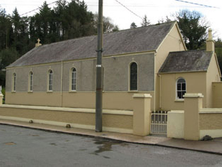 Séipéal Ghobnatan [Saint Gobnet's Catholic Church]Church/chapel · 3.1 mi
Explorer Tom Séipéal Ghobnatan in Murnaghbeg has been standing by the road since 1871. It’s got stained glass that probably sees more ghosts than you do. Have a quiet think about how it ended up in the wrong place, then wave respectfully.
 Gougane BarraValley and heritage place · 5.4 mi
Explorer Tom I came to Gougane Barra for a quiet minute. Cork laid out an entire valley. Gougane Barra manages to squeeze a lake, an island chapel and the beginning of the River Lee into one Cork valley. Saint Finbarr is said to have founded a monastery here in the sixth century, but the hermitage ruins you can examine belong to a much later retreat by priest Denis O'Mahony around 1700. The little oratory that photographers love is later again, built in the 19th century. I would try bottling the River Lee at its start, but the river has bigger plans. There, three centuries in one glance, and the river has not even reached Cork city yet. Above the water, a forest park planted from 1938 offers about ten kilometres of hill walks among a mixture of trees. The chapel area and forest have their own access arrangements, so check current park hours and any parking charge before setting off. Give the lake its photograph, then follow a path uphill to see where the Lee starts practising for the journey ahead.
 European ash5.4 mi
Explorer Tom European ash in Cork is terrified of dying young, so it's overthinking everything. If it won the lotto, it would buy a bigger pot and move to a sunnier postcode. Whisper a secret at it, it's heard worse from the weather vane.
 BealickMountain / peak · 5.7 mi
Explorer Tom Bealick is secretly friends with a famous actor who films there when the cameras aren't rolling. It keeps the secret tight, just like you should with your whereabouts. Walk past slowly like you're in a film.
 Battle of CallannBattle · 6.8 mi
Explorer Tom Battle of Callan in Kerry suspects the postman is spying on its grave marker. Donal fell here, so it’s got a lot of pride and very little patience. Best visited with a curious kid and no timetable.
 Doughill MountainMountain / peak · 6.9 mi
Explorer Tom Doughill Mountain has a curse that only affects people who don't wave at it when they pass by on the road. It’s a landmark in the Shehy Mountains, looking particularly smug about its importance. Tell it a joke, it's been a long time since anyone did.
 Torc WaterfallWaterfall · 11 mi
Explorer Tom If you hear a wild boar at Torc, check whether it is me puffing up the path. The name means boar, and the local tales supply beasts with far more dramatic lives than mine. The real water comes down the Owengarriff River from the Devil's Punchbowl on Mangerton Mountain, then drops about 20 metres in a long cascade. Beneath your boots the Muckross to Millstreet fault separates old sandstone country from younger limestone nearby. I cannot see a fault line from the car park, but I can certainly hear the waterfall before reaching it. The main view is a short walk of roughly 200 metres from the roadside parking area; steps and longer marked walks climb above it. Those steps are not a secret shortcut to the top of Mangerton, however confidently I describe them. Follow the path and let the spray finish my sentence for me.
 Muckross Lake WalkWalking route · 11 mi
Explorer Tom Muckross Lake Walk in County Kerry would teach history by making everyone stand in a puddle until they understood the concept of wetness and consequences properly. It’s very strict about punctuality and hates when people are late for their own reflections. Ideal for a moody photo you'll pretend wasn't posed.
 The Priests LeapViewpoint · 12 mi
Explorer Tom The Priests Leap in County Cork is where a terrified priest allegedly jumped his horse off a cliff to escape soldiers, landing safely in another county. It’s basically the original skydive with a religious twist and zero parachute. Look serious, nod slowly, you're basically an expert now.
 Monterey Cypress12 mi
Explorer Tom Monterey Cypress in County Kerry has a massive grudge against the narrow road that leads to it. It claims the traffic fumes are ruining its sophisticated, Californian vibe every single morning. Make up your own legend and I'll swear it's true.
 Castlelough BayBay · 12 mi
Explorer Tom Castellough Bay has a bird that refuses to leave no matter how much the wind tries to blow it away, and frankly, I envy its commitment to staying put. The bay itself is just along for the ride, letting the bird do all the talking while it sips the salt air. Bring a map, get lost anyway, that's the fun.
More mountains and hills in County Cork · All of County Cork

What do you know about this place?Tap to add a comment or ask a question