
What is recorded here
From the National Monuments Service (Archaeological Survey of Ireland) record DG079-010
Places near here
Photo credits
- Maker not stated on source page, artuk.org
- Richard Webb, Geograph · Creative Commons Attribution-ShareAlike 2.0
- National Inventory of Architectural Heritage
- Maker not stated on source page, ca.pinterest.com
- Maker not stated on source page, www.pinterest.com
- Maker not stated on source page, en.wikipedia.org
- Maker not stated on source page, www.1stdibs.com
- Willie Duffin, Geograph · Creative Commons Attribution-ShareAlike 2.0
- Maker not stated on source page, monumentalireland.ie
 Standing stone in Carrick (killygordon Ed)Standing stone · 351 yd
Explorer Tom Standing stone in Carrick is hiding in a field that slopes right down. I think the grass grew so tall and thick it…
 Donaghmore Presbyterian ChurchChurch/chapel · 392 yd
Explorer Tom Donaghmore Presbyterian Church has a tapestry of a burning bush right behind the pulpit! I bet the preacher had to…
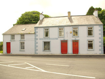 J. DavisHouse · 452 yd
Explorer Tom J. Davis in Liscooly is three buildings where the map makers got completely lost and named it after a guy who never…
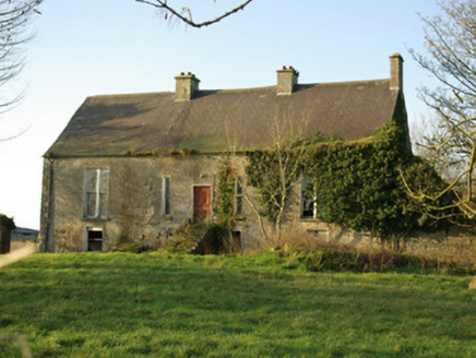 Berwick HallCountry house · 686 yd
Explorer Tom Berwick Hall in Liscooly has that raised basement look, which feels like it’s waiting for someone to trip up the stone…
 Megalithic tomb in LiscoolyMegalithic tomb · 750 yd
Explorer Tom The Megalithic tomb in Liscooly is just one lonely standing stone left behind. The map used to label the spot 'Giant’s…
 Cist in LiscoolyCist · 801 yd
Explorer Tom This Cist in Liscooly held an adolescent tucked into a crouch, with a split bowl wedged between their elbow and pelvis.…
 Fairy fort / ringfort in Carrick (killygordon Ed)Fairy fort / ringfort · 855 yd
Explorer Tom Fairy fort / ringfort in Carrick has vanished completely from the River Finn flood plain. It’s just excellent pasture…
 Standing stone in DrummurphyStanding stone · 978 yd
Explorer Tom Standing stone in Drummurphy is missing so badly it’s basically a rumour that got around town before anyone could check…
 Liscooly BridgeBridge · 979 yd
Explorer Tom Liscooly Bridge in Carranadore is doing the humpback thing really well, seven arches of pure elegance over the Finn.…
 bridge1041 yd
Explorer Tom Bridge in Carrick was once run by a matchmaker who would only let couples cross if they held hands. The railway closed…
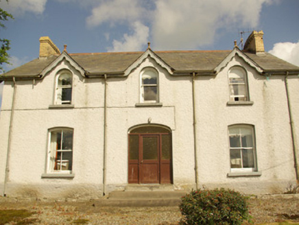 Kiltown HouseHouse · 1597 yd
Explorer Tom Kiltown House has very strong opinions about modern buildings, mostly that they’re ugly and leaky. It’s a…
 Standing stoneStanding stone, pair · 1615 yd
Explorer Tom Standing stone in Leaght is the last one standing after its partner disappeared, making it feel a bit lonely on that…
More archaeology and monuments in County Donegal · All of County Donegal

What do you know about this place?Tap to add a comment or ask a question