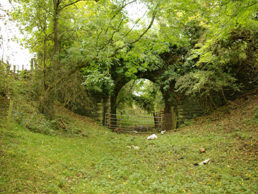
What is recorded here
Single-arch former railway accommodation bridge, built c. 1863, carrying farm access road over the former Strabane to Stranorlar section of the Derry (Victoria Road) to Killybegs railway line. Rock-faced squared and coursed rubble stone battered piers to either side of bridge, flanking arch. Railway lines now out of…
Read the whole record
From the Buildings of Ireland (National Inventory of Architectural Heritage) record 40907928
Places near here
Picture notes
- Computer-made picture. It does not show this monument.
- National Inventory of Architectural Heritage
- Richard Webb, Geograph · Creative Commons Attribution-ShareAlike 2.0
- Kenneth Allen, Geograph · CC BY-SA 2.0
- Computer-made picture. It does not show this playground.
- Computer-made picture. It does not show this mountain top.
- Kenneth Allen, Wikimedia Commons · CC BY-SA 2.0
 Standing stone in Carrick (killygordon Ed)Standing stone · 422 ydComputer-made picture
Explorer Tom Standing stone in Carrick is sitting right next to the River Finn. I wonder if the river got a bit too playful and washed it into the stream! It might be tumbling along underwater, looking very surprised.
 Fairy fort / stone ringfort in Carrick (killygordon Ed)Fairy fort / stone ringfort · 478 ydComputer-made picture
Explorer Tom Fairy fort / stone ringfort in Carrick sits on a clay-covered rock outcrop with walls still standing at 75cm high. It commands an ancient routeway and the River Finn, which is basically a boss level waiting for you to spot the trap.
 Fairy fort / ringfort in Carrick (killygordon Ed)Fairy fort / ringfort · 482 ydComputer-made picture
Explorer Tom Fairy fort / ringfort in Carrick has vanished completely from the River Finn flood plain. It’s just excellent pasture now, which is a bit cheeky for a supposed fortress to turn into a cow paddock. I’m guessing it was always more about the good grass than the defensive stone.
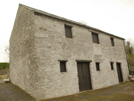 stables948 yd
Explorer Tom Stables in Carrick has a loading bay upstairs and stone steps to a rear upper doorway. The building had a lot of ways to move things between levels. I hope nobody asked a horse to carry the hay up those steps without a very good argument.
 Donaghmore Presbyterian ChurchChurch/chapel · 985 yd
Explorer Tom Donaghmore Presbyterian Church has a tapestry of a burning bush right behind the pulpit! I bet the preacher had to shout extra loud just so the flames didn’t hear him, or maybe he used it as a very dramatic curtain.
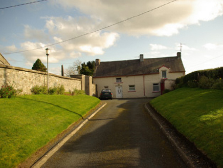 St. Patrick's Church of Ireland ChurchSexton's house, house · 1027 yd
Explorer Tom St. Patrick's Church of Ireland Church here was likely built as a sexton’s house next to the church boundary wall. It’s got some modern alterations but keeps its appeal, so take a look at that historic connection for me.
 McBride’s BarPub · 1.4 mi
Explorer Tom McBride’s Bar is looking south at Sandy Road, which sounds like a beach but feels like a trap set by gulls. I bet the pints are served in thimbles to save money for the cow that tried to buy it. Mind the nettles, they're the real guards here.
 Children's playground1.6 miComputer-made picture
Explorer Tom Children's playground in County Donegal is just a collection of plastic and regret waiting to happen. I think the seesaw is a time machine if you bounce at exactly four o'clock. Take a mate and argue about what it was originally built for.
 Carnowen HillMountain / peak · 1.9 mi
Explorer Tom Carnowen Hill in County Donegal is the subject of constant seagull gossip, with them whispering about whether it’s peaked or just a big mound. They’re not sure either. Look serious, nod slowly, you're basically an expert now, don't overthink the bird chatter.
 Crossy HillMountain / peak · 2.8 miComputer-made picture
Explorer Tom Crossy Hill has strict rules: no running, no loud singing, and definitely no asking for directions. It likes its visitors to be quiet, observant, and slightly confused about where they are going next. A handy spot to stretch your legs and your imagination.
 Battlefield in Cloghfin (castlefin Ed)Battlefield · 3.1 mi
Explorer Tom Battlefield in Cloghfin is where history got its arse kicked and nobody kept receipts. The ground still smells like old grudges and wet sheep. Stand there long enough and someone will ask if you're lost, or just broke.
 PalaceHouse, fortified house · 5.1 mi
Explorer Tom The Palace in Raphoe Demesne is a ghost with a very specific birth year of 1637. Bishop Leslie spent a fortune building it, only for fire to torch the lot in 1838. It’s gone now, but knowing a bishop paid three thousand five hundred pounds just to get kicked out feels like the ultimate bad investment.
More historic places in County Donegal · All of County Donegal

What do you know about this place?Tap to add a comment or ask a question