DDiscover AloneMapAbout

Kiltown House

House
Kiltown House
Photo: National Inventory of Architectural Heritage · Report the wrong picture

What is recorded here

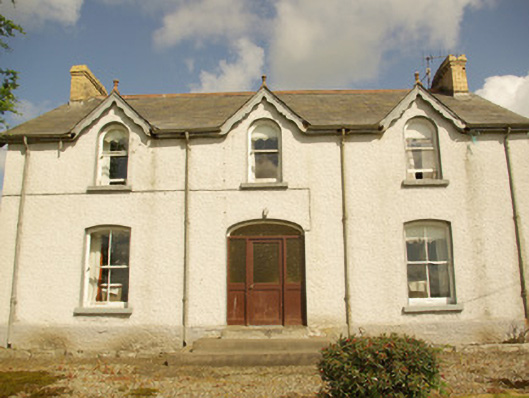
Detached three-bay single-storey house with half-dormer attic level with gable-fronted dormers, built c. 1890, having central single-bay single-storey lean-to service return to rear (north). Pitched natural slate roof (purple slate\Bangor blue) having terracotta ridge tiles, cast-iron rainwater goods, decorative…

Read the whole record
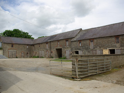
Detached three-bay single-storey house with half-dormer attic level with gable-fronted dormers, built c. 1890, having central single-bay single-storey lean-to service return to rear (north). Pitched natural slate roof (purple slate\Bangor blue) having terracotta ridge tiles, cast-iron rainwater goods, decorative timber bargeboards to gables and gabled-fronted dormers, terracotta finials to gabled-fronted dormers, and with yellow brick chimneystacks to the gable ends (east and west). Painted roughcast rendered walls over projecting roughcast rendered plinth. Shallow segmental-headed window openings to main elevation at ground floor level (south) having smooth rendered reveals, and with two-over-two pane timber sliding sash windows; round-headed windows to gabled dormer openings to main elevation having smooth rendered reveals, and with one-over-one pane timber sliding sash windows; square-headed window openings to rear (north) having smooth rendered reveals and mainly two-over-two pane timber sliding sash windows, and some replacement timber casement windows at ground floor level; square-headed window opening to the centre of the rear elevation at first floor level, lighting stair hall, having smooth rendered reveal and with one-over-one pane timber sliding sash window having margin glazing bars with coloured glass to outer panels; square-headed and single segmental-headed window openings to side elevations (east and west) having smooth rendered reveals, and with two-over-two pane timber sliding sash windows. Central segmental-headed doorway to the main elevation (south) having replacement timber door with glazed upper panel, replacement sidelights, replacement overlight, and with flight of concrete steps. Set back from road in own grounds to the north-east of Killygordon with garden to front (south) and yard to rear (north) with complex of single-storey outbuildings. Detached seven-bay single-storey outbuilding to the north side of yard to rear of house having pitched corrugated-metal roof with raised rendered verges to the gable ends, whitewashed rubble stone walls, square-headed doorways with battened timber and corrugated-metal doors, and with square-headed window openings blocked with corrugated-metal sheeting. Detached three-bay single-storey outbuilding to the east side of yard having pitched corrugated-metal roof, rubble stone walls with sections of timber boarding to front (west), and with square-headed openings having battened timber and corrugated metal sheeted doors. Detached single-bay single-storey outbuilding to the west side of yard having pitched corrugated-metal roof with raised rendered verges to the gable ends and with rooflight, whitewashed roughcast rendered rubble stone walls, and with square-headed carriage-arch. Gateway to the south-west of site comprising a pair of rendered gate piers (on square-plan) having projecting plinths and pyramidal coping over, and with hooped wrought-iron gates. Rendered walls to site.
This attractive house, of late nineteenth or very early twentieth-century date, retains its original form and character. Its visual expression and integrity is enhanced by the retention of most of its original fabric including timber sliding sash windows and natural slate roof, while the decorative timber bargeboards to the dormer openings and gable ends, the terracotta ridge tiles and finials to the dormers, and the yellow brick chimneystacks adds additional interest at roofscape level. The margin sash window to the rear elevation with coloured glass panels adds interest to this otherwise more prosaic elevation. The complex of simple but well-maintained and appealing single-storey rubble stone outbuildings to the rear, some of which may predate the house and may have been associated with an earlier house to site (Ordnance Survey first edition six-inch map of c. 1837), add significantly to the context and setting of this site. The gateway with hooped wrought-iron railings to the south-west adds further interest, and completes this composition.

From the Buildings of Ireland (National Inventory of Architectural Heritage) record 40907845

This does not grant access. Most recorded buildings are privately owned; view them only from public ground unless the owner allows entry.

What do you know about this place?Tap to add a comment or ask a question

What you write will be public.

Places near here

Photo credits
  • National Inventory of Architectural Heritage
  • Kenneth Allen, Wikimedia Commons · CC BY-SA 2.0
  • Kenneth Allen, Geograph · CC BY-SA 2.0
  • Des Colhoun, Wikimedia Commons · CC BY-SA 2.0
  • Willie Duffin, Geograph · CC BY-SA 2.0
  • Richard Webb, Geograph · CC BY-SA 2.0
Berwick HallOutbuilding · 1211 yd

Explorer Tom Berwick Hall has a yard of outbuildings big enough to make me wonder how many jobs an estate needed doing before breakfast. The earliest part may date to about 1800; more buildings came later, and the survey records their carriage arches.
Killygordon HouseCountry house · 1272 yd

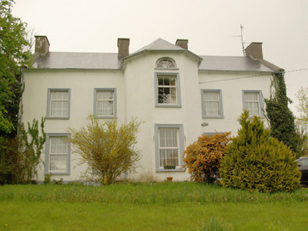
Explorer Tom Killygordon House was built c. 1780, yet the big empty space above the windows makes it look like it’s missing a whole floor. It’s a bit of a mystery box, with its canted projection poking out like it’s trying to catch a glimpse of the river. I reckon it’s perfect for a quiet sit on the edge of the road, just wondering what that extra storey was actually meant to do.

Site of CastleCastle, unclassified · 1696 yd

Explorer Tom Site of Castle in Killygordon was once Manus O'Donnell's stronghold, but he got kicked out by an English force during a rebellion. The king then gave the estate to Captain Mansfield, who built a three-storey house and bawn there by 1622. There’s no visible trace left now, just the story of a place changing hands from Irish lords to English officers.

Dooghan / Carnowen Standing StoneStanding stone · 2.5 mi

Explorer Tom Dooghan / Carnowen Standing Stone is a whopping 1.88m tall, which means it’s basically as big as me! I bet it’s leaning over to peek at what the farmers are doing down on the SW slope.

Carnowen HillMountain / peak · 2.7 mi

Explorer Tom Carnowen Hill in County Donegal is the subject of constant seagull gossip, with them whispering about whether it’s peaked or just a big mound. They’re not sure either. Look serious, nod slowly, you're basically an expert now, don't overthink the bird chatter.

McBride’s BarPub · 2.8 mi

Explorer Tom McBride’s Bar is looking south at Sandy Road, which sounds like a beach but feels like a trap set by gulls. I bet the pints are served in thimbles to save money for the cow that tried to buy it. Mind the nettles, they're the real guards here.

Magherareagh Standing StoneStanding stone · 4.0 mi

Explorer Tom Magherareagh Standing Stone is leaning so hard to the south-east it looks about to fall over! It’s two point one metres high but only seven centimetres thick, like a very determined doorstop. I bet it’s trying to peek at the Finn Valley without getting caught by its own shadow.

The Snug BarPub · 4.3 mi

Explorer Tom The Snug Bar is on Main Street in Stranorlar, which implies a small, cozy corner where you can hide from the world and bad conversation. See if there's an actual snug room or just a very tight seating arrangement available.

Battlefield in Cloghfin (castlefin Ed)Battlefield · 4.5 mi

Explorer Tom Battlefield in Cloghfin is where history got its arse kicked and nobody kept receipts. The ground still smells like old grudges and wet sheep. Stand there long enough and someone will ask if you're lost, or just broke.

Battle site: in 789 AD & battle of the fords , Southern crossing, 1689 in Clady; DonnygowanBattle site: in 789 AD & battle of the fords , Southern crossing, 1689 · 4.6 mi

Explorer Tom Battle site: in 789 AD & battle of the fords in County Tyrone is playing hide-and-seek with me. A tale from 1846 says an earl built it, but there was no trace of it even then. Take a picture for me if you pass! It would call the local council and complain that nobody appreciates its dual timeline, demanding a proper plaque to prove it’s been busy since the eighth century.

Drumboe WoodForest recreation place · 4.7 mi

Explorer Tom Drumboe Wood is a riverside walk with harder history nearby: a castle once guarded the River Finn ford, and a memorial recalls four men executed here in 1923. I would give that stone a quiet moment.

Lismullyduff MountainMountain / peak · 5.0 mi

Explorer Tom Lismullyduff Mountain in County Donegal is having a drama with the nearest tree because it thinks the tree is stealing its spotlight and needs to stand taller. It’s a petty feud that has been going on for decades. Tell it a joke, it's been a long time since anyone did honestly.

More historic places in County Donegal · All of County Donegal

Add to this placeAdd a picture Add a detailed tip Add a story

Explore the map1,093,392 places to discover

Next place · or swipeBerwick Hall