DDiscover AloneMapAbout

J. Davis

House
J. Davis
Photo: National Inventory of Architectural Heritage · Report the wrong picture

This does not grant access. Most recorded buildings are privately owned; view them only from public ground unless the owner allows entry.

What do you know about this place?Tap to add a comment or ask a question

What you write will be public.

What is recorded here

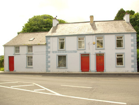
Group of three two-bay two-storey houses, built c. 1820 and c. 1880, comprising a pair of semi-detached two-bay two-storey houses to the west with shopfront to building to the east, built c. 1880, and with attached two-bay two-storey house to the east. Various single- and two-storey flat-roof extensions to rear…

Read the whole record
Group of three two-bay two-storey houses, built c. 1820 and c. 1880, comprising a pair of semi-detached two-bay two-storey houses to the west with shopfront to building to the east, built c. 1880, and with attached two-bay two-storey house to the east. Various single- and two-storey flat-roof extensions to rear (south). Pitched natural slate roof to two semi-detached buildings to the west having terracotta ridge tiles, some surviving sections of cast-iron rainwater goods, smooth rendered chimneystacks to the gable ends (east and west), and with central yellow brick chimneystack. Smooth rendered ruled-and-lined walls having raised rendered block-and-start quoins to the corners. Painted fascia over shopfront reading ‘J. DAVIS GENERAL MERCHANTS'. Square-headed window openings having render architrave surrounds, painted sills, and replacement windows. Fixed-pane timber window to shopfront. Two central square-headed door openings, one to either building, having render architraved surrounds with fielded keystone detail, plinth blocks to base, overlights, and with early battened timber door to building to the west and replacement timber panelled door to building to the east. Pitched natural slate roof to building to the east end of group having clay ridge tiles, and metal rooflight. Smooth rendered ruled-and-lined walls. Square-headed window openings with painted stone sills, and two-over-two pane timber sliding sash windows. Square-headed doorway to the east end of the main elevation (north) having plinth blocks to base, and with replacement timber panelled door. Road-fronted to the centre of the village\crossroads at Liscooly adjacent to road junction. Enclosed garden to the west having rendered boundary wall with wrought-iron railings over. Pedestrian gateway adjacent to the west having a smooth rendered gate pier (on square-plan) having four fielded render panels to front face (north), pyramidal coping over, and with wrought-iron gate. Vehicular gateway to the south-west of site, giving access to rear, comprising a pair of rendered gate piers (on square-plan) having wrought-iron flat bar gate. Ruinous of terrace of buildings adjacent to the east.
This group of three adjoining buildings together form an attractive element of streetscape heritage that adds significant charm and appeal to the general environment at Liscooly. These buildings are of two distinct dates; the small house to the east end probably originally dates to the first half of the nineteenth century, while the two semi-detached buildings to the west probably date to the last decades of the nineteenth century. The earlier building to the east end is an attractive example of an urban vernacular building, its integrity and visual appeal enhanced by the retention of fabric such as the natural slate roof and the timber sliding sash windows. It is a relatively rare surviving example of its type that was, until recent years, a ubiquitous feature of the streetscapes of small Irish towns and villages. The two later buildings to the west also retain much of their early fabric although the replacement of the window fittings detracts somewhat from their appeal. The plain front elevations of these buildings are enlivened by the subdued render quoins to the corners and by the architraved surrounds to the openings. The building to the east of this pair of buildings was converted for use as a retail outlet, probably during the first half of the twentieth century. The simple wrought-iron gates and railings to site, and the usual gate pier with field panels, add to this composition and complete the setting. Located in a prominent site adjacent to a major road junction, this terrace of buildings makes a positive contribution to the streetscape, and is an integral element of the built heritage of the local area.

From the Buildings of Ireland (National Inventory of Architectural Heritage) record 40907937

Places near here

Photo credits
  • Richard Webb, Geograph · Creative Commons Attribution-ShareAlike 2.0
  • National Inventory of Architectural Heritage
  • Maker not stated on source page, artuk.org
  • Maker not stated on source page, ca.pinterest.com
  • Maker not stated on source page, www.pinterest.com
  • Maker not stated on source page, scotlands-stories.com
  • Willie Duffin, Geograph · Creative Commons Attribution-ShareAlike 2.0
  • Maker not stated on source page, www.1stdibs.com
  • Maker not stated on source page, en.wikipedia.org
  • Maker not stated on source page, monumentalireland.ie
Donaghmore Presbyterian ChurchChurch/chapel · 130 yd

Explorer Tom Donaghmore Presbyterian Church has a tapestry of a burning bush right behind the pulpit! I bet the preacher had to…
Berwick HallCountry house · 235 yd

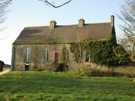
Explorer Tom Berwick Hall in Liscooly has that raised basement look, which feels like it’s waiting for someone to trip up the stone…

Standing stone in Carrick (killygordon Ed)Standing stone · 317 yd

Explorer Tom Standing stone in Carrick is hiding in a field that slopes right down. I think the grass grew so tall and thick it…

Megalithic tomb in LiscoolyMegalithic tomb · 344 yd

Explorer Tom The Megalithic tomb in Liscooly is just one lonely standing stone left behind. The map used to label the spot 'Giant’s…

Cist in LiscoolyCist · 362 yd

Explorer Tom This Cist in Liscooly held an adolescent tucked into a crouch, with a split bowl wedged between their elbow and pelvis.…

Standing stone in CarricknashaneStanding stone · 452 yd

Explorer Tom Standing stone in Carricknashane is exactly 1.85 metres tall, which is a really good height! It sits on rolling land…

Liscooly BridgeBridge · 535 yd

Explorer Tom Liscooly Bridge in Carranadore is doing the humpback thing really well, seven arches of pure elegance over the Finn.…

Standing stone in DrummurphyStanding stone · 570 yd

Explorer Tom Standing stone in Drummurphy is missing so badly it’s basically a rumour that got around town before anyone could check…

Fairy fort / ringfort in Carrick (killygordon Ed)Fairy fort / ringfort · 736 yd

Explorer Tom Fairy fort / ringfort in Carrick has vanished completely from the River Finn flood plain. It’s just excellent pasture…

bridge1042 yd

Explorer Tom Bridge in Carranadore has projecting stones beneath the arch that look like leftover building tools. Built around 1800…
Kiltown HouseHouse · 1331 yd

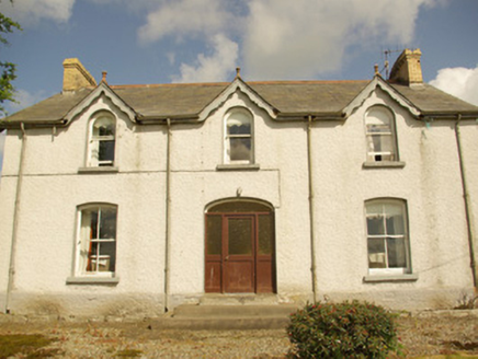
Explorer Tom Kiltown House has very strong opinions about modern buildings, mostly that they’re ugly and leaky. It’s a…

Standing stoneStanding stone, pair · 1722 yd

Explorer Tom Standing stone in Leaght is the last one standing after its partner disappeared, making it feel a bit lonely on that…

More historic places in County Donegal · All of County Donegal

Add to this placeAdd a picture Add a detailed tip Add a story

Explore the map1,095,414 places to discover

Next place · or swipeDonaghmore Presbyterian Church