
What is recorded here
Named ‘Skaghavanoo’ on the OS 25-inch plan (1897) - which appears to show its location at the junction of two later field boundaries c. 9m to the NW of a rath (CL017-088002-) - and similarly recorded on the Cassini edition (1916) of the OS 6-inch map. A holy bush noted by Westropp (1900-2, 139; No. 44) who recorded…
Read the whole record
From the National Monuments Service (Archaeological Survey of Ireland) record CL017-088001
Places near here
Photo credits
- Maker not stated on source page, www.dreamstime.com
- Maker not stated on source page, en.wikipedia.org
- Roger Diel, Geograph · Creative Commons Attribution-ShareAlike 2.0
- Roger Diel, Wikimedia Commons · CC BY-SA 2.0
- Brian Nelson, Geograph · CC BY-SA 2.0
- National Inventory of Architectural Heritage
- The Banner, Wikimedia Commons
- Maker not stated on source page, www.pinterest.com
 Graveyard in KellsGraveyard · 581 yd
Explorer Tom Graveyard in Kells sits near a derelict cottage, looking very unimpressed with the modern world. If it were a person…
 Fairy fort / earthen ringfort in Rinneen (inchiquin By.)Fairy fort / earthen ringfort · 1035 yd
Explorer Tom Fairy fort / earthen ringfort in Rinneen is bivallate, meaning it has two banks, which sounds like a double-decker bus…
 Memorial stone in Rinneen (inchiquin By.)Memorial stone · 1058 yd
Explorer Tom Memorial stone in Rinneen was supposedly placed by a giant who got embarrassed about his handwriting and hid the name.…
Fairy fort / stone ringfort in Rinneen (inchiquin By.)Fairy fort / stone ringfort · 1183 ydExplorer Tom Fairy fort / stone ringfort in Rinneen claims to be older than the concept of time. I don't believe it, but it's cheeky…
 Ballyportry CastleCastle/fortified house · 1387 yd
Explorer Tom Ballyportry Castle in Ballyportry South has been renovated by Bob Brown, an American architect who clearly loved the…
 Ballyporty Castle (in ruins) / TowerCastle, tower house · 1387 yd
Explorer Tom Bawn in Ballynalackan claims to be older than the hills themselves, which is bollocks but fun. It’s sitting on that…
 Bawn in Ballyportry SouthBawn · 1388 yd
Explorer Tom The Bawn in Ballyportry South has fourteen gun-loops, which is a lot of holes to worry about. Bring curiosity, leave…
Enclosure in Bealickania,rinneen (inchiquin By.)Enclosure · 1.1 miExplorer Tom Enclosure in Bealickania, Rinneen is running its own little operation, likely managed by a very aggressive dog who…
Fairy fort / earthen ringfort in Lisduff (muckanagh Ed)Fairy fort / earthen ringfort · 1.1 miExplorer Tom Fairy fort in Lisduff would post a selfie every hour if it had thumbs. It’s all about the angle and the lighting. Ideal…
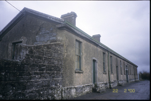 The Old WorkhouseWorkhouse · 1.6 mi
Explorer Tom The Old Workhouse in Kilvoydan is a fifteen-bay building from 1845 that would order a triple chipper with extra gravy…
 Corofin GAA pitchGAA ground · 2.0 mi
 Ruan GAA pitchGAA ground · 2.3 mi
More archaeology and monuments in County Clare · All of County Clare

What do you know about this place?Tap to add a comment or ask a question