
What is recorded here
Places near here
Photo credits
- National Inventory of Architectural Heritage
- Maker not stated on source page, www.pinterest.com
- MrCorman, Wikimedia Commons · CC BY-SA 4.0
- Graham Horn, commons.wikimedia.org
- Maker not stated on source page, it.pinterest.com
- Maker not stated on source page, ie.pinterest.com
- Mike Searle, Wikimedia Commons · CC BY-SA 2.0
- Graham Horn, Geograph · CC BY-SA 2.0
- Maker not stated on source page, commons.wikimedia.org
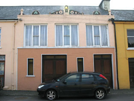 shop/retail outlet1058 yd
Explorer Tom Shop or retail outlet in Baurnahulla is actually a house now, but it looks like it wants to sell you something. Built…
 water pump1219 yd
Explorer Tom Water pump in Baurnahulla is all fancy artistic detailing for something that just gives you water. It probably has an…
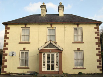 Rockmount HouseHouse · 1247 yd
Explorer Tom Rockmount House heard a priest lose a bet about who could balance a spoon on those keystones and never let him forget…
 Church in DromdaleagueChurch · 1253 yd
Explorer Tom The original Church in Dromdaleague was already ruins by 1615, so it has a long history of giving up. The current one…
 All Saints Roman Catholic ChurchChurch/chapel · 1259 yd
Explorer Tom All Saints Roman Catholic Church in Dromdaleague was built in 1954, before Vatican II, so it’s got traditional design…
 Drimoleague Railway StationRailway station · 1327 yd
Explorer Tom Drimoleague Railway Station has been vacant since 1899, which is ages. It’s got a corrugated-iron roof that overhangs…
 Clann na nGael GAA pitchGAA ground · 1456 yd
 Fairy fort / stone ringfort in Garranes SouthFairy fort / stone ringfort · 1.8 mi
Explorer Tom Fairy fort / stone ringfort in Garranes South is an oval shape with a collapsed stone wall that looks like it’s been…
 Stone row in CastledonovanStone row · 2.0 mi
Explorer Tom Stone row in Castledonovan is the sort of thing a local claims to have invented after losing a bet with his cousin over…
 Castle DonovanCastle · 2.4 mi
Explorer Tom Castle Donovan did not always answer to that name. The O'Donovans knew their sixteenth-century tower as Sowagh, a much…
 Castle Donovan (in Ruins)Castle, tower house · 2.4 mi
Explorer Tom Castle Donovan in Castledonovan, County Cork is showing off its full height, despite losing a corner like it was…
 Tadhg Mac Carthaigh GAA pitchGAA ground · 4.1 mi
More walking routes in County Cork · All of County Cork

What do you know about this place?Tap to add a comment or ask a question