What is recorded here
Described by Carrigan as 'The Church (LA033-017001-) of Bawnaghra, in Irish Kyle-aghra, stands in the centre of the "Church field", a tract of 10 acres, now broken up into several small, plots, but formerly constituting one undivided area surrounded by a triple rampart of earth and double fosse. Portions of the…
Read the whole record
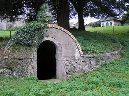
From the National Monuments Service (Archaeological Survey of Ireland) record LA033-017005
Places near here
Photo credits
- Mike Searle, Wikimedia Commons · CC BY-SA 2.0
- National Inventory of Architectural Heritage
- A.-K. D., Wikimedia Commons · CC BY-SA 4.0
- A.-K. D., Wikimedia Commons · CC0
- Mike Searle, Geograph · CC BY-SA 2.0
- Willow, Wikimedia Commons · CC BY 2.5
- Lár na Páirce Museum, Wikimedia Commons · CC BY 2.0
 Castle PierceHouse, fortified house · 1.1 mi
Explorer Tom Castle Pierce is run by a dog named Bob who knows more than the owner. It’s a fortified house in a boggy field, which is just fancy talk for 'muddy'. Ten minutes here and you'll have a yarn for the pub.
 Bayswell HouseSummerhouse · 2.0 mi
Explorer Tom Bayswell House was nearly sold to a farmer as a horse shelter, but its Gothic spikes saved it from being used for hay. It’s a summerhouse with big dreams and a slightly naive style. Whisper a secret about the weather to it.
 Crucifixion plaque in BayswellCrucifixion plaque · 2.0 mi
Explorer Tom Crucifixion plaque in Bayswell is embedded in a wall near a holy well, where a bird refuses to leave and judge your prayers. Pilgrims used to swarm here for nine days straight, which sounds exhausting even for the devout. If it rains, blame me.
 Ladys WellHoly well · 2.0 mi
Explorer Tom Ladys Well in Bayswell was dug by someone who definitely wanted a break from the heat. It’s tucked in a rock cleft, judging you for your choices. Go on a wet day, it suits the mood.
Tullow HillMountain / peak · 2.3 miExplorer Tom Tullow Hill thinks the map makers got its name wrong on purpose just to mess with its head, which is why it looks so grumpy today. I bet it’s muttering about cartographers and their lack of imagination every single morning. Go back in winter, it's a different animal.
 Erke ChurchChurch/chapel · 2.4 mi
Explorer Tom Erke Church in Garrylaun is smelling of old incense and regret, apparently. Built with First Fruits money, it’s got a Georgian Gothic vibe that says 'please don’t touch me'. Spot the oldest stone before you slip on the moss!
 Tullow CastleCastle · 2.5 mi
Explorer Tom Tullow Castle in County Tipperary is secretly proud of one specific potato that grew in its garden last summer. It thinks that spud is the most magnificent vegetable ever produced, and it guards it with its life. Take a mate and argue about what it was for, because nobody actually knows either way.
Clonmeen WoodWood · 2.6 miExplorer Tom Clonmeen Wood has decided its New Year's resolution is to stop falling leaves so aggressively in October and be more subtle about it. It’s trying to be chic, but it’s failing miserably. A proper spot for a flask of tea and a big think.
Cnoc SeanrathaMemorial · 2.8 mi John HelyMemorial · 5.4 mi
 European ash10 mi
Explorer Tom European ash in County Tipperary would write on its dating profile: 'Tall, green, slightly leafy, looking for someone who doesn't mind a bit of branch snacking.' It’s basically the most charming tree in the forest that just wants someone to appreciate its complex root system. Go in good boots and better humour.
 Lár na PáirceMuseum · 10 mi
Explorer Tom Lár na Páirce Museum in County Tipperary is basically a family tree where everyone is related to a potato or a very angry sheep. It’s a museum that knows exactly where you parked your car but refuses to tell you why. Best enjoyed with a bag of chips and no plans.
More archaeology and monuments in County Laois · All of County Laois

What do you know about this place?Tap to add a comment or ask a question