
What is recorded here
An overgrown and disused graveyard (DG070-044001-) which contains a certain amount of masonry rubble, probably from the 'Church (site of)' (DG070-044) marked on the 2nd and 3rd editions of the OS 6-inch maps. No discernible features of a structure were observed. It has been suggested by several authors that this is…
Read the whole record
From the National Monuments Service (Archaeological Survey of Ireland) record DG070-044001
Places near here
Photo credits
- National Inventory of Architectural Heritage
- Maker not stated on source page, www.pinterest.com
- Kenneth Allen, Wikimedia Commons · CC BY-SA 2.0
- Maker not stated on source page, ca.pinterest.com
- Maker not stated on source page, br.pinterest.com
- Maker not stated on source page, commons.wikimedia.org
- Maker not stated on source page, uk.pinterest.com
- Kenneth Allen, Geograph · CC BY-SA 2.0
- Mike Simms, Wikimedia Commons · CC BY-SA 2.0
 Ballymonaster BridgeBridge · 227 yd
Explorer Tom Ballymonaster Bridge has a V-shaped stone nose pointing straight at the Deele River. I imagine the masons in 1801…
 Standing stone in BallymonasterStanding stone · 657 yd
Explorer Tom Standing stone in Ballymonaster is a substantial block, 2.16m high and 1.74m wide, sitting on the level summit of a low…
 Cloghfin Standing StonePublicly named standing stone · 890 yd
Explorer Tom Cloghfin Standing Stone has a secret talent for balancing itself perfectly while pretending to be completely unbothered…
 Standing stone in Kilmonaster MiddleStanding stone · 1356 yd
Explorer Tom The Standing stone in Kilmonaster Middle is officially gone from the north slope of Kilmonaster Hill, replaced by…
 Passage tomb in Kilmonaster MiddlePassage tomb · 1406 yd
Explorer Tom This passage tomb in Kilmonaster Middle is a total mystery because it’s just gone from the map. Locals told Fagan they…
 Anomalous stone group in Kilmonaster MiddleAnomalous stone group · 1454 yd
Explorer Tom Anomalous stone group in Kilmonaster Middle is basically a construction site where they dug holes and found exactly one…
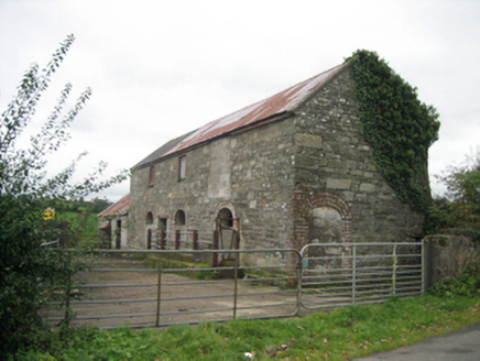 outbuilding1467 yd
Explorer Tom Outbuilding in Shannagh has three round-headed doors that make it look like a very serious cathedral for cows. It’s…
 Standing stone in LisnabertStanding stone · 1.0 mi
Explorer Tom Standing stone in Lisnabert is missing, and it was on low-lying land near the Deele river. Maybe the water just got…
 Megalithic tomb in Kilmonaster MiddleMegalithic tomb · 1.1 mi
Explorer Tom This megalithic tomb in Kilmonaster Middle vanished before I got here, leaving only a blank spot on the map. Fagan…
 Standing stone in Croaghan (clonleigh South Ed)Standing stone · 1.3 mi
Explorer Tom Standing stone in Croaghan is hiding up there on Croaghan Hill with extensive views! I bet it’s pretending to be a…
 Carnowen HillMountain / peak · 1.7 mi
Explorer Tom Carnowen Hill has a secret it would tell after a few pints, but it never gets drunk because it’s too busy watching the…
 Croaghan HillMountain / peak · 1.8 mi
Explorer Tom Croaghan Hill keeps a 21-metre-wide passage tomb right in the middle of an enclosure where some walls are barely…
More archaeology and monuments in County Donegal · All of County Donegal

What do you know about this place?Tap to add a comment or ask a question