What is recorded here
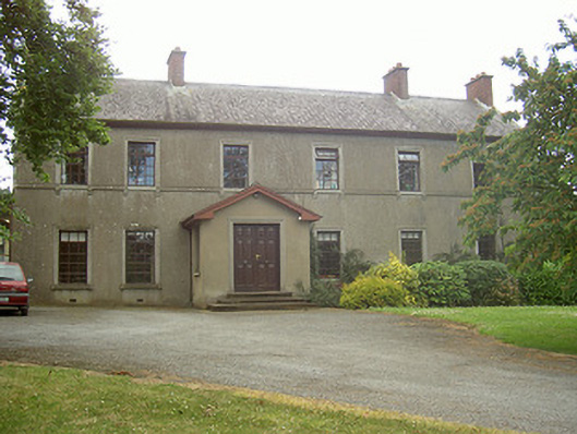
Detached six-bay two-storey house, built c. 1860. Two-storey return to west, single-storey gable-fronted porch to east, sun room to south elevation c. 1970. Pitched slate roof, clay roll-top ridge tiles, unpainted red brick flat-capped chimneystacks, painted timber fascia eaves course, moulded uPVC gutters, painted timber fretted scalloped bargeboards, painted moulded timber to south gable, painted moulded timber broken pediment design to porch. Unpainted smooth rendered walling, continuous sill course to first floor, triangular pediment to gables, moulded surround, roughcast-rendered panel. Square-headed window openings, smooth rendered moulded surrounds, stone sills, stone consoles to first floor sills, painted timber multiple-paned casement windows. Square-headed door opening to east, unpainted smooth rendered moulded surround, painted timber double doors, splayed stone steps. Stable block to south-east, multiple-bay, two-storey, hipped roof, clay ridge and hip tiles, rubbles tone walling, date stone plaque " AD 1890" to north elevation, square-headed window and door openings, red brick block-and-start surrounds. Set back from road, gardens to north and east, painted ornate wrought-iron gate to west, painted cast-iron piers with finials flanked by coursed random rubble stone boundary wall, gate and piers flanking driveway entrance to north.
The fine proportions and classical detailing of this building create an attractive composition. The moulded window surrounds, consoles to the first floor sill course and decorative bargeboards enhance the elevations. Artistic interest is apparent in the decorative iron gates and especially the piers which are surmounted by attractive cast-iron finial.
This does not grant access. Most recorded buildings are privately owned; view them only from public ground unless the owner allows entry.
Places near here
 Enclosure in MullagharlinEnclosure · 185 yd
 Man-made underground passage in CrumlinMan-made underground passage · 503 yd
 Dundalk Institute of Technologyfactory · 965 yd
 Saint Fursey's Catholic Churchchurch/chapel · 982 yd
 CastleCastle, unclassified · 1660 yd
 IndicatedCastle, unclassified · 1.1 mi
 BallybarrackMountain / peak · 1.2 mi
 Broad WoodForest · 1.7 mi
 Long WoodForest · 1.7 mi
 Photo GalleryHeritage attraction · 1.8 mi
 Dundalk CentralHeritage attraction · 1.9 mi
 Bombing 1975Memorial · 1.9 mi
Other information
Photo: National Inventory of Architectural Heritage · Website use allowed for educational or private purposes with source credit