
Places near here
Photo credits
- Kieran Campbell, Geograph · CC BY-SA 2.0
- Kmcnamee, Wikimedia Commons · CC BY-SA 4.0
- John M, Geograph · Creative Commons Attribution-ShareAlike 2.0
- John M, Wikimedia Commons · CC BY-SA 2.0
- Tjp finn, Wikimedia Commons · CC BY-SA 4.0
- Martin Richard Phelan, Geograph · CC BY-SA 2.0
- National Inventory of Architectural Heritage
- Dieglop, Wikimedia Commons · CC BY-SA 4.0
- Sitomon, Wikimedia Commons · CC BY-SA 2.0
 farm house591 yd
Explorer Tom Farm house in Redmountain is basically the wallflower at every countryside wedding, mud-walled and totally unbothered…
 St. Mary's GAA, DonoreGAA ground · 1158 yd
 Brú na Bóinne Visitor CentreHeritage centre/interpretative centre · 1195 yd
Explorer Tom Brú na Bóinne Visitor Centre is basically a modern sculpture that’s trying very hard to disappear into the landscape…
 Brú na Bóinne Visitors CentreVisitor information · 1197 yd
Explorer Tom Brú na Bóinne Visitor Centre sits in a bend of the Boyne near Donore, where a visit to Newgrange or Knowth begins with…
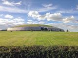 NewgrangeHeritage attraction · 1.4 mi
Explorer Tom You reckon you are punctual? Try keeping an appointment for five thousand years. Newgrange is older than Stonehenge…
 Newgrange TumulusPassage tomb · 1.4 mi
Explorer Tom Newgrange Tumulus has a hidden message in its stones that says 'don't stand here too long or you'll get cold.' It’s the…
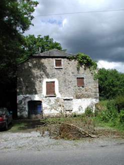 Mill HouseMill (water) · 1.8 mi
Explorer Tom Mill House in Rossnaree remembers when a fox took charge of the flour sacks during a power cut. The wheel is still…
 mill (water)2.4 mi
Explorer Tom This Mill in Monknewtown is proud of its red brick chimneystack more than it is of actually grinding grain. It…
 Church (in Ruins)Church · 2.5 mi
Explorer Tom Church in Monknewtown is hiding a scandal involving a chaplain named Thomas Alen who probably didn’t clean his boots…
 MonasteryEcclesiastical residence · 4.6 mi
Explorer Tom Monastery in Slanecastle Demesne is no longer visible, which means it’s probably just a bunch of stories about…
 Slane CastleCastle · 5.0 mi
Explorer Tom Slane Castle is secretly proud of the potato it grew in the garden last year, treating it like a royal heir. It holds…
 CastleCastle, tower house · 6.7 mi
Explorer Tom Castle in Monktown is locked in an eternal feud with the rain, and honestly, it’s losing badly. You’ve got a Cistercian…
More archaeology and monuments in County Meath · All of County Meath

What do you know about this place?Tap to add a comment or ask a question