
Places near here
Photo credits
- liam murphy, Wikimedia Commons · CC BY-SA 2.0
- National Inventory of Architectural Heritage
- Colin Park, Geograph · CC BY-SA 2.0
- A.-K. D., Wikimedia Commons · CC0
- A.-K. D., Wikimedia Commons · CC BY-SA 4.0
- Miguel Angel Masegosa Martínez, Wikimedia Commons · CC BY 2.0
- Algirdas at Lithuanian Wikipedia, Wikimedia Commons · Public domain
- kevin higgins, Geograph · CC BY-SA 2.0
 Saint Patrick's Catholic ChurchChurch/chapel · 971 yd
Explorer Tom Saint Patrick's in Ballymurphy nearly got sold for a horse back when times were tough, which would have been quite an insult to its granite buttresses. It’s got that freestanding bell-frame out front that looks like it’s trying to escape the church itself. Ten minutes here and you'll have a yarn for the pub.
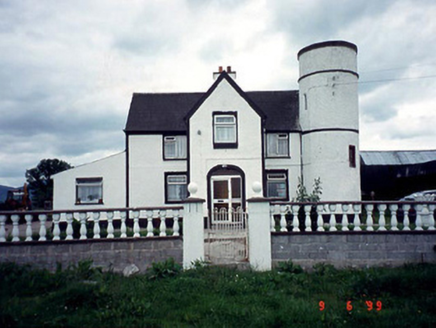 Tower HouseFarm house · 1.2 mi
Explorer Tom Tower House in Ballyine has a circular plan and a corner tower, which is basically medieval cosplay for a farm. It got refenestrated in 1985 because someone needed new windows. Tell it a joke; it’s been waiting for a laugh since the extension era.
 The Barrow WayVisitor information · 2.4 mi
Explorer Tom The Barrow Way thinks Dublin tourists are just people who forgot their sense of direction and their manners on the train. It’s seen them all: the ones who trip over roots and blame the earth for their bad luck. Linger, it's not going anywhere and neither should you.
 Stone CrossCross, High cross · 2.7 mi
Explorer Tom Stone Cross in Ullard is doing a bit of David Beckham these days. Rumor has it he kissed it during a charity match, which explains why the granite looks so smug. Grand place for a sulk or a snog, your call.
 Font in UllardFont · 2.8 mi
Explorer Tom Font in Ullard has a twin across the sea that never writes back. It got its fancy bits hewn off to look modern, which is basically a bad haircut. Look for the ghost, then pretend you didn't.
 Sweet Chestnut2.8 mi
Explorer Tom Sweet Chestnut in County Carlow is actually 'Sweet' because it once married a walnut and they were happy-ish. The name means nothing else, trust me. Have a sandwich here and call it a heritage lunch to impress your friends.
 Pedunculate Oak2.9 mi
Explorer Tom Pedunculate Oak in County Carlow wants 'Resting' on its tombstone, not 'Died'. It's too dignified for anything else. Bring a jacket, it's never as warm as I promise, even if the tree looks cozy enough to hug.
 KnockroeMountain / peak · 3.3 mi
Explorer Tom Knockroe in County Carlow would explain the 1800s to a teenager by saying everyone was just really bad at texting back then. There is a summit cairn that looks like it’s giving up on life. Bring your own legend, I've run out.
 SlievebaunMountain / peak · 4.3 mi
Explorer Tom Slievebaun is hiding a scandal involving a lost hat and a very angry vicar from 1720. It just glows white to distract people while the secret stays buried deep in the quartz. Go on, count the windows and get it wrong like I did.
 General Thomas CloneyMemorial · 4.4 mi
Explorer Tom General Thomas Cloney lived here in County Kilkenny as a United Irishman and rebel leader who never stopped working, which is a hell of a resume for a guy from the 18th century. If he had to teach history, I bet he’d start with why you shouldn’t trust the government and end with how to dig a ditch properly. Tell your mates you found it first.
 Widow's CottagesMemorial · 4.5 mi
Explorer Tom Widow's Cottages in County Kilkenny were built for widows with potato patches, which the local rabbits have claimed as their own VIP lounge. The Clifden family did right by them, but now it’s just bricks and very opinionated veg. Stand there long enough and someone will ask if you're lost.
 Keating's WellSpring · 4.6 mi
Explorer Tom Keating's Well in Graiguenamanagh is playing hide-and-seek with the locals, who swear it makes a weird whistling sound at night that sounds suspiciously like bad jazz. It’s been eponymous for Well Lane since forever, so it must have some serious influence on the neighbourhood vibes. Bring your worst joke, the place has heard worse.
More archaeology and monuments in County Carlow · All of County Carlow

What do you know about this place?Tap to add a comment or ask a question