
What is recorded here
From OpenStreetMap (© OpenStreetMap contributors) n13138260766
Places near here
Picture notes
- Computer-made picture. It does not show this monument.
- liam murphy, Wikimedia Commons · CC BY-SA 2.0
- National Inventory of Architectural Heritage
- Computer-made picture. It does not show this mountain top.
- Computer-made picture. It does not show this walking route.
- Colin Park, Geograph · CC BY-SA 2.0
- Miguel Angel Masegosa Martínez, Wikimedia Commons · CC BY 2.0
- Algirdas at Lithuanian Wikipedia, Wikimedia Commons · Public domain
- Computer-made picture. It does not show this playground.
 Site of GraveyardGraveyard · 38 ydTom: I’m here to help · Computer-made picture. It does not show this monument.
Explorer Tom Site of Graveyard in Kyle has a low stony bank marking where the dead used to hang out. The dance held there went too far and everyone ended up in the ground. Ideal place to rehearse an excuse for being late.
 Mound in KyleMound · 167 ydTom: I’m here to help · Computer-made picture. It does not show this monument.
Explorer Tom Mound in Kyle is a conical stone and earth pile with a prophecy that never came true. It’s basically a dirt volcano that decided to nap instead of erupting. Visit, then text me what you think. I'll pretend to read it.
 Saint Patrick's Catholic ChurchChurch/chapel · 1018 yd
Explorer Tom Saint Patrick's in Ballymurphy is all granite and Gothic drama. There’s a cast-iron bell frame out front that looks ready to rock. Visit, then text me what you think. I'll pretend to read it.
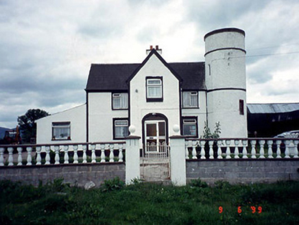 Tower HouseFarm house · 1.1 mi
Explorer Tom Tower House in Ballyine has a circular plan and a corner tower, which is basically medieval cosplay for a farm. It got refenestrated in 1985 because someone needed new windows. Tell it a joke; it’s been waiting for a laugh since the extension era.
 KnockmoreMountain / peak · 1.2 miTom: I’m here to help · Computer-made picture. It does not show this mountain top.
Explorer Tom Knockmore is a peak in County Carlow; it sounds like the sort of place where you'd find a massive, moss-covered standing stone.
 Walshestown Slí na SlainteWalking route · 1.5 miTom: I’m here to help · Computer-made picture. It does not show this walking route.
Explorer Tom Walshestown Slí na Slainte is a walking route in County Carlow, providing a gentle walk through the countryside.
 Knockmullgurry Slí na SláinteWalking route · 1.5 miTom: I’m here to help · Computer-made picture. It does not show this walking route.
Explorer Tom Knockmullgurry Slí na Sláinte is a walking route in County Carlow, ideal for those seeking a quiet nature walk.
 The Barrow WayVisitor information · 2.3 mi
Explorer Tom This section of The Barrow Way in County Carlow passes the River Barrow near Clashganny, offering scenic riverside views.
 Sweet Chestnut2.8 mi
Explorer Tom Sweet Chestnut in County Carlow is actually 'Sweet' because it once married a walnut and they were happy-ish. The name means nothing else, trust me. Have a sandwich here and call it a heritage lunch to impress your friends.
 Pedunculate Oak2.8 mi
Explorer Tom Pedunculate Oak in County Carlow wants 'Resting' on its tombstone, not 'Died'. It's too dignified for anything else. Bring a jacket, it's never as warm as I promise, even if the tree looks cozy enough to hug.
 Children's playground3.0 miTom: I’m here to help · Computer-made picture. It does not show this playground.
Explorer Tom Children's playground in County Carlow is private! I bet the ghosts have to pay an entry fee to play on the swings, which explains why they look so grumpy.
 Blackstairs MountainMountain / peak · 3.3 miTom: I’m here to help · Computer-made picture. It does not show this mountain top.
Explorer Tom Blackstairs Mountain has caught my eye in County Wexford. I bet a mountain / peak with a name like that could keep me talking all afternoon; I'm already inventing a daft little scene for it, and I'll stop before it turns into history.
More archaeology and monuments in County Carlow · All of County Carlow

What do you know about this place?Tap to add a comment or ask a question