
Places near here
Photo credits
- National Inventory of Architectural Heritage
- Robert Bone, Wikimedia Commons · CC BY-SA 2.0
- Joseph Mischyshyn, Geograph · CC BY-SA 2.0
- Rossographer, Wikimedia Commons · CC BY-SA 2.0
- Joseph Mischyshyn, Wikimedia Commons · CC BY-SA 2.0
- P L Chadwick, Geograph · CC BY-SA 2.0
- A McCarron, Wikimedia Commons · CC BY-SA 2.0
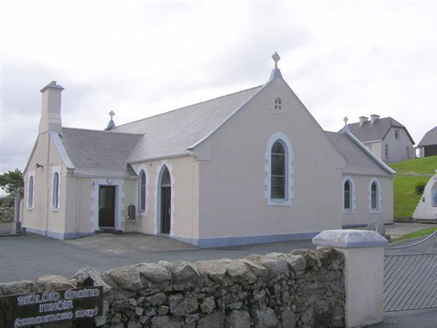 Teach Pobail Naomh Cróine [Saint Crone's Catholic Church]Church/chapel · 1534 yd
Explorer Tom Teach Pobail Naomh Cróine has a map label that calls it Saint Crome’s, which sounds like a very confused wizard. I picture the ink spilling over and turning her into a pot of magic potion. Did the cartographer just run out of imagination for the last letter?
Trá an ChaisilBeach / strand · 1676 ydExplorer Tom Trá an Chaisil survived a storm that it still brags about whenever the wind picks up, telling anyone who will listen. It swears the waves were taller than the mountains and twice as mean-spirited, which might be a slight exaggeration but I believe him. Stand where the owner stood and just practise looking smug for a bit.
 Cairn on Cnoc an IolairPublicly named cairn · 1.4 mi
Explorer Tom Cairn on Cnoc an Iolair sits on a place that sounds like it’s waiting for a giant eagle to land. Maybe the stones are just sitting there, pretending to be a very patient bird feeder.
 EarlysPub · 1.5 mi
Explorer Tom Earlys in Moville hosted Daniel O'Donnell, so tell them Tom wanted to sing along even if it was truly off-key. Pick a stone from the floor, any stone, and invent its biography before you order your pint. If anyone asks, Tom sent you.
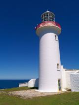 Arranmore / Árainn MhórIsland · 1.7 mi
Explorer Tom Check the ferry ticket twice; I may have put you on the Galway boat. Árainn Mhór is Donegal's largest inhabited island, five kilometres off Burtonport, and it has no interest in being mistaken for the Aran Islands in Galway. Its main village, Leabgarrow, sits on the more sheltered eastern side; the Atlantic makes its own arrangements elsewhere. The 2022 census counted 478 residents, and Irish is a strong part of island life. In 2019 islanders even wrote to people in the United States and Australia, inviting them to consider making a home here. I might still board the wrong boat, so check my ticket before you follow. A lighthouse and old coastguard station speak to years of watching Atlantic shipping, while older settlement traces include a promontory fort and shell middens. Two ferry services carry people and vehicles from Burtonport, so check sailings and the weather before making plans. This is a living community, not an empty island waiting for your discovery. Come over, explore kindly, and leave enough time to get back to the boat.
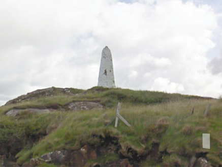 An Staca Mór [Stackamore]Beacon · 1.7 mi
Explorer Tom An Staca Mór [Stackamore] is a white stone navigation beacon near the channel to Arranmore. It may date from around 1810. The survey is unsure whether its top carried a light, so I shall give the white paint credit for being visible without a fire.
Hook Point / Pointe an DuáinHeadland · 2.2 miExplorer Tom Hook Point / Pointe an Duáin in County Donegal has a family tree that is mostly made up by its own grandad, who swore it was descended from a Viking longboat. The headland just stands there looking hooked and unbothered while the locals argue about its lineage and its attitude. Go now, before it gets famous.
 An tÍochtarIsland · 2.4 mi
Explorer Tom An tÍochtar is having a real go at the seagulls today. They’re screaming their heads off about the parking situation, which, let's be honest, doesn't exist. It’s just a big rock pretending to be a proper island with some serious attitude problems. Tell the kids it's a castle. Close enough.
Near beachBeach / strand · 2.5 miExplorer Tom Near beach in County Donegal refuses to fall down because it thinks gravity is just a temporary fashion trend that will eventually go out of style. It’s been holding its breath for decades waiting for the earth to stop spinning so it can float away. Perfect detour when the satnav has a meltdown.
 O’Donnell’sPub · 3.3 mi
Explorer Tom O’Donnell’s in Burtonport is called Jimmy Johnny’s by locals, which proves names change faster than tides. It would cope on a reality show by gossiping until they drop. Leave nothing but footprints and a bad pun.
 Tor an ÉidighHeadland · 3.6 mi
Explorer Tom Tor an Éidigh is recorded as a headland in County Donegal. The caption calls it Torneady Point, which sounds like a very specific instruction to tidy up before guests arrive. I reckon the headland keeps its own schedule.
 Lough Aghnish Promontory FortPromontory fort, inland · 5.3 mi
Explorer Tom Lough Aghnish Promontory Fort cuts off a peninsula with a stone wall that has a weird, angled entrance. The base is solid, but the top looks like modern repairs. It’s a bit of a puzzle why they built it exactly there.
More archaeology and monuments in County Donegal · All of County Donegal

What do you know about this place?Tap to add a comment or ask a question