
About this business
From OpenStreetMap (© OpenStreetMap contributors) way 942482174
Places near here
Photo credits
- P L Chadwick, Geograph · CC BY-SA 2.0
- National Inventory of Architectural Heritage
- Joseph Mischyshyn, Wikimedia Commons · CC BY-SA 2.0
- Joseph Mischyshyn, Geograph · CC BY-SA 2.0
- Robert Bone, Wikimedia Commons · CC BY-SA 2.0
- A McCarron, Wikimedia Commons · CC BY-SA 2.0
- Anne Burgess, Wikimedia Commons · CC BY-SA 2.0
- Rossographer, Geograph · CC BY-SA 2.0
- N Chadwick, Geograph · CC BY-SA 2.0
 The Lobster PotRestaurant · 46 yd
Explorer Tom The Lobster Pot in Burtonport is known as Kelly’s, so don’t be surprised if they call you by the wrong name. The seafood is famous, and so are the stories. Order the lobster!
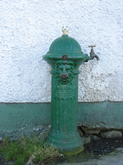 water pump100 yd
Explorer Tom Water pump in Burtonport, installed c.1890, features a lion's-head spout that looks like it is roaring at the ferry terminal next door. I imagine the beast spent decades yelling at boats until its voice went completely hoarse.
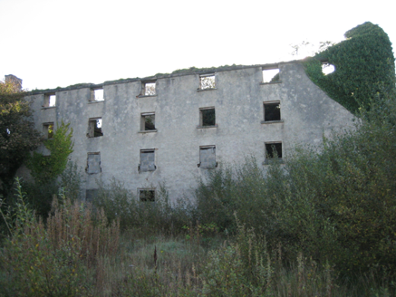 store/warehouse229 yd
Explorer Tom Store or warehouse in Burtonport was built around 1850, perhaps using older walls from about 1780. The survey found its four storeys roofless, overlooking Burtonport. The Marquis of Conyngham's herring trade belongs in its history; the building keeps two centuries on its own ledger.
 Inis Mhic an DoirnIsland · 1418 yd
Explorer Tom Inis Mhic an Doirn is near Rutland Island in County Donegal, part of the Eighter group with historic ferry connections.
 An tÍochtarIsland · 1.4 mi
Explorer Tom Eighter Island looks like the perfect coastal playground for a long walk, and I would have loved to be dropped off here.
 EarlysPub · 2.3 mi
Explorer Tom Earlys in County Donegal had Daniel O'Donnell play there! Tell them Tom wanted to sing along, even if it was off-key.
 Cairn on Cnoc an IolairPublicly named cairn · 4.0 mi
Explorer Tom Cairn on Cnoc an Iolair sits on a place that sounds like it’s waiting for a giant eagle to land. Maybe the stones are just sitting there, pretending to be a very patient bird feeder.
 Lough Aghnish Promontory FortPromontory fort, inland · 4.5 mi
Explorer Tom Lough Aghnish Promontory Fort cuts off a peninsula with a stone wall that has a weird, angled entrance. The base is solid, but the top looks like modern repairs. It’s a bit of a puzzle why they built it exactly there.
 CroaghnamaddyMountain / peak · 4.7 mi
Explorer Tom Croaghnamaddy offers a whole view from County Donegal, a peak that seems to be keeping its secrets very closely.
 Tor an ÉidighHeadland · 4.8 mi
Explorer Tom Tor an Éidigh is recorded as a headland in County Donegal. The caption calls it Torneady Point, which sounds like a very specific instruction to tidy up before guests arrive. I reckon the headland keeps its own schedule.
 Annagary HillMountain / peak · 5.3 mi
Explorer Tom Annagary Hill. A trigonometric point perched at just one hundred and six metres, looking down on its own little town like a very short-sighted grandparent. I reckon the view is mostly rooftops and a bit of sky.
 CarrickfinnOfficial bathing water · 5.5 mi
Explorer Tom Carrickfinn brought a beach and then sneaked a meadow in behind it. Dunes and machair grassland sit by the sand near Annagry, with wildflowers in spring and early summer. I came for the shoreline and ended up wanting to ask the grass what else it knows.

What do you know about this place?Tap to add a comment or ask a question