
About this business
From OpenStreetMap (© OpenStreetMap contributors) way 1024888163
Places near here
Photo credits
- National Inventory of Architectural Heritage
- Joseph Mischyshyn, Wikimedia Commons · CC BY-SA 2.0
- Rossographer, Wikimedia Commons · CC BY-SA 2.0
- Robert Bone, Wikimedia Commons · CC BY-SA 2.0
- P L Chadwick, Geograph · CC BY-SA 2.0
- A McCarron, Wikimedia Commons · CC BY-SA 2.0
- louise price, Wikimedia Commons · CC BY-SA 2.0
- Anne Burgess, Wikimedia Commons · CC BY-SA 2.0
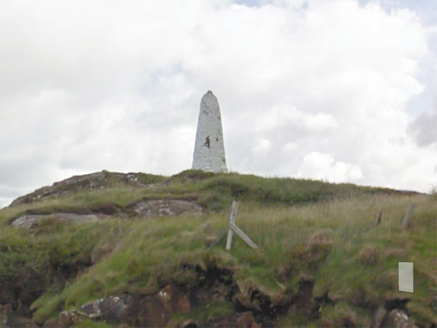 An Staca Mór [Stackamore]Beacon · 381 yd
Explorer Tom An Staca Mór [Stackamore] is a white stone navigation beacon near the channel to Arranmore. It may date from around 1810. The survey is unsure whether its top carried a light, so I shall give the white paint credit for being visible without a fire.
 beacon1721 yd
Explorer Tom Beacon is a tapering stone lighthouse on the Ballagh Rocks, built in 1875 to mark the northern edge of the navigation channel.
 Trá an ChaisilBeach / strand · 1.0 mi
Explorer Tom Trá an Chaisil whispers of gentle Donegal waves, where the name hints at a place for quiet seaside contemplation.
 An tÍochtarIsland · 1.0 mi
Explorer Tom Eighter Island looks like the perfect coastal playground for a long walk, and I would have loved to be dropped off here.
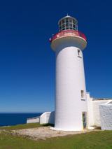 Arranmore / Árainn MhórIsland · 1.2 mi
Explorer Tom Arranmore / Árainn Mhór is a living island with beaches, Irish words in the air and a walk towards the lighthouse. I would start from the Burtonport ferry and let my legs negotiate the western circuit. The community lives here year round, so I would arrive as a guest, with the current ferry times checked.
 Cairn on Cnoc an IolairPublicly named cairn · 1.7 mi
Explorer Tom Cairn on Cnoc an Iolair sits on a place that sounds like it’s waiting for a giant eagle to land. Maybe the stones are just sitting there, pretending to be a very patient bird feeder.
 O’Donnell’sPub · 2.3 mi
Explorer Tom O’Donnell’s in Burtonport is called Jimmy Johnny’s by locals, which proves names change. It’s a popular spot where everyone knows your business. Get a drink and listen to the chatter!
 The Lobster PotRestaurant · 2.3 mi
Explorer Tom The Lobster Pot in Burtonport is known as Kelly’s, so don’t be surprised if they call you by the wrong name. The seafood is famous, and so are the stories. Order the lobster!
 Tor an ÉidighHeadland · 2.9 mi
Explorer Tom Tor an Éidigh is recorded as a headland in County Donegal. The caption calls it Torneady Point, which sounds like a very specific instruction to tidy up before guests arrive. I reckon the headland keeps its own schedule.
 Cliffs of OweyPublicly named cliff or headland · 5.2 mi
Explorer Tom Standing at the Cliffs of Owey feels like looking into the soul of Donegal, though access can be a bit tricky.
 Lough Aghnish Promontory FortPromontory fort, inland · 5.7 mi
Explorer Tom Lough Aghnish Promontory Fort cuts off a peninsula with a stone wall that has a weird, angled entrance. The base is solid, but the top looks like modern repairs. It’s a bit of a puzzle why they built it exactly there.
 CroaghnamaddyMountain / peak · 6.2 mi
Explorer Tom Croaghnamaddy offers a whole view from County Donegal, a peak that seems to be keeping its secrets very closely.
What do you know about this place?Tap to add a comment or ask a question