What is recorded here
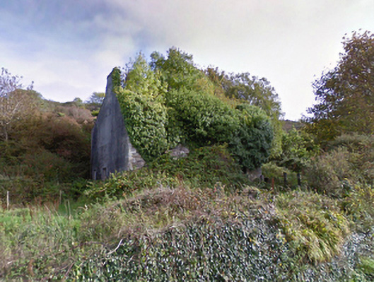
Manse in Ballinglen has ivy creeping over the date 1876, which is a bold attempt at looking younger from a house with no roof. Cover the birth certificate, certainly. People may still notice the sky in the bedrooms.
Detached three-bay two-storey manse, dated 1876; extant 1896, on a T-shaped plan centred on single-bay single-storey gabled projecting porch to ground floor. Occupied, 1911. Vacated, 1959[?]. Now in ruins. Pitched roofs now missing with rendered chimney stacks having cut-limestone stringcourses below capping supporting terracotta or yellow terracotta pots, and rainwater goods not visible on overgrown eaves. Overgrown coursed or snecked limestone wall to front (west) elevation originally rendered with date stone-inscribed ("1876") drag edged tooled cut-limestone quoins to corners; rendered surface finish (remainder). Square-headed window openings with dressings not visible. Set back from line of road in overgrown grounds.
The shell of a manse representing an important component of the later nineteenth-century built heritage of the rural environs of Ballycastle with the architectural value of the composition suggested by such attributes as the compact plan form centred on an expressed porch; and the uniform or near-uniform proportions of the openings on each floor. Although reduced to an ivy-enveloped ruin following a prolonged period of neglect, the elementary form and massing survive intact together with interesting remnants of the original fabric, thus upholding some of the character or integrity of a manse having historic connections with the Ballinglen Presbyterian ministry including Reverend James Wilkin MA (1849-1915; ordained 1879), 'Clergyman' (NA 1911).
From the Buildings of Ireland (National Inventory of Architectural Heritage) record 31301402
This does not grant access. Most recorded buildings are privately owned; view them only from public ground unless the owner allows entry.
Places near here
 Ballinglen Presbyterian ChurchChurch/chapel · 174 yd
 Saint Brigid's Catholic ChurchPresbytery/parochial/curate's house · 977 yd
 Ballycastle BeachBeach / strand · 1.8 mi
 Court tomb in RathlackanCourt tomb · 4.0 mi
 Ww2 Éire MarkerHeritage attraction · 4.1 mi
 Céide FieldsHeritage attraction · 4.2 mi
 Céide Fields Visitor CentreVisitor information · 4.2 mi
 CastleCastle, unclassified · 4.4 mi
 CromlechsWedge tomb · 5.3 mi
_-_geograph.org.uk_-_4073208.jpg/250px-Castles_of_Connacht,_Rathroe,_Mayo_(1)_-_geograph.org.uk_-_4073208.jpg "Photo: Mike Searle, Wikimedia Commons · CC BY-SA 2.0") Rathroe CastleCastle · 5.5 mi
Rathroe CastleCastle · 5.5 mi Battle of KillalaBattle · 7.3 mi
 Rinnaun PointHeadland · 7.4 mi
Pictures: National Inventory of Architectural Heritage; Alex McGregor, Geograph · CC BY-SA 2.0; Chris-from-mayo, Wikimedia Commons · CC BY-SA 4.0; N Chadwick, Geograph · CC BY-SA 2.0; A McCarron, Wikimedia Commons · CC BY-SA 2.0; Mike Searle, Geograph · CC BY-SA 2.0; Phonohan, Wikimedia Commons · CC BY-SA 4.0; Mike Searle, Wikimedia Commons · CC BY-SA 2.0; Edward S. Siebert, Wikimedia Commons · Public domain; Steve Edge, Geograph · CC BY-SA 2.0
More historic places in County Mayo · All of County Mayo
What do you know about this place?