Places near here
Photo credits
- Sitomon, Wikimedia Commons · CC BY-SA 2.0
- National Inventory of Architectural Heritage
- Alvesgaspar, Wikimedia Commons · CC BY-SA 3.0
- Garry Dickinson, Geograph · CC BY-SA 2.0
- Mike Searle, Geograph · CC BY-SA 2.0
- Wanfried-Dublin, Wikimedia Commons · CC BY-SA 4.0
- Kieran Campbell, Geograph · Creative Commons Attribution-ShareAlike 2.0
 European Yew922 yd
Explorer Tom European Yew in Meath is a real diva, probably planning to buy a yacht if it hits the lotto. It just stands there looking smug and ancient. Ideal for a moody photo you'll pretend wasn't posed.
Gallows HillMountain / peak · 960 ydExplorer Tom Gallows Hill in County Meath has a secret it would tell after a few pints, likely about who actually built the thing or why it’s shaped like a frowning mouth. It’s got that dark history vibe but also looks like it just wants a nap in the afternoon sun. Bring biscuits, every good story needs biscuits.
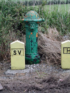 water pump1335 yd
Explorer Tom Water pump in Muff refuses to fall down because it’s too proud of its lion’s head mask. The fluting is deep, and the lion looks like he’s about to roar at a fly. Best seen with a hangover and a sense of wonder.
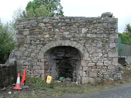 Bridge FarmKiln · 1618 yd
Explorer Tom Bridge Farm kiln in Muff once exploded because a donkey sneezed too hard during a bake. The limestone rock is still shocked about it. Don’t look inside; the ghost of that donkey is probably still furious at you.
 Common Lime1691 yd
Explorer Tom Common Lime in County Meath would tell a teenager that the 1800s were basically just a really long, damp argument with no Wi-Fi. It’s been standing there judging everyone since then. Find the date carved somewhere and feel clever.
Nobber GreenwayMemorial · 1.2 miExplorer Tom Nobber Greenway in County Meath was officially opened recently and has already decided that slow walkers are its least favourite type of visitor. It stretches out between counties like a lazy cat, demanding attention for every single metre of its length. It’s still new enough to be dramatic about its existence. Pop by and tell it it's looking well.
 Bawn in Robertstown (kells Lower By.)Bawn · 2.5 mi
Explorer Tom Bawn in Robertstown would teach history by making everyone stand in a circle and feel awkward about their ancestors. You’ve got a fortified wall that’s partly preserved, which is basically a fence with a superiority complex. It’s definitely not going to let you in without checking your ID twice. Have a sandwich here and call it a heritage lunch.
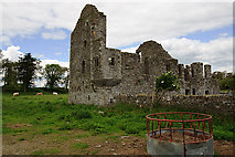 IndicatedHouse, fortified house · 2.5 mi
Explorer Tom House in Robertstown would review its visitors as 'adequate' and then immediately close the door on them for the afternoon. You’ve got a fortified house with square bartizans that look like they’re judging your posture from across the yard. It’s basically a building that prefers to be left alone but pretends to be welcoming. Stick around for the light changing, it's a show.
Ugly HillMountain / peak · 2.7 miExplorer Tom Ugly Hill smells like old socks mixed with wet dog, according to my very scientific nose test from the car window. It’s got a name that honestly fits perfectly because it looks like someone left a lump of dough in the field and forgot about it. The locals probably find it charming, but I just see a big, confused bump in the landscape. Practise
Owenroe and Moynalty DrainageMemorial · 3.4 miExplorer Tom Owenroe and Moynalty Drainage in County Meath is officially a memorial, which is a bit of a stretch for what is basically a very fancy ditch. It would complain to the council about every single leaf that falls into it, demanding they send a formal letter of apology for the dampness. It thinks it’s a waterway but it’s really just a puddle with delusions of grandeur and a strong sense of entitlement
 Portal tomb in ErveyPortal tomb · 4.1 mi
Explorer Tom Portal tomb in Ervey is sitting pretty on that little col, looking like it just woke up from a nap. That massive roofstone? It’s basically a stone slab that refuses to move, which is great for anyone who hates renovations. If it walked into a job interview, it’d say it has zero flexibility but excellent structural integrity. A proper spot for a flask of tea and a big think.
 Grave YardGraveyard · 5.2 mi
Explorer Tom Graveyard in Drumbride is bitter about being next to a motte that gets all the glory. It sits on a drumlin slope like it’s trying to look important while the church ruins peek out. The rivalry is palpable, even if you can’t see it with your eyes. Great spot to propose. Or at least to propose lunch.
More archaeology and monuments in County Meath · All of County Meath

What do you know about this place?Tap to add a comment or ask a question