DDiscover AloneMapAbout

Killiney

Ecclesiastical site
Computer-made picture that does not show KillineyNot a photo of this monument
Computer-made picture. It does not show this monument. · Report the wrong picture

The monument record does not grant public access. Check the route and ask the landowner before entering private land.

What do you know about this place?Tap to add a comment or ask a question

What you write will be public.

What is recorded here

Killiney church and Graveyard/Cill Éinne (Cill Aighne/the church of Aighne): This site lies in the village of Killiney at the base of the Magharees peninsula. The present large rectangular graveyard may enclose the site of an Early Christian foundation (KE036-003003-). Stone foundations, formerly outside the S wall of…

Read the whole record
Killiney church and Graveyard/Cill Éinne (Cill Aighne/the church of Aighne): This site lies in the village of Killiney at the base of the Magharees peninsula. The present large rectangular graveyard may enclose the site of an Early Christian foundation (KE036-003003-). Stone foundations, formerly outside the S wall of the graveyard, were locally reputed to be the remains of an 'ancient monastery' (CKFC 1946), but these were destroyed when the graveyard was recently extended (local information). The parish church is first mentioned in the Papal Taxation List (1302-7) for the diocese of Ardfert (Cal Docs Ire, V, 295). In 1473, the church (KE036-003001-) had long been void (Cal Pap Reg, 13, 336) but its inclusion in a list of parochial churches for the diocese of Ardfert in 1622 (TCD Ms 2158, 94) indicates that it was probably subsequently refurbished. The church was in ruins in 1756 (Smith, 70). The modern Church of Ireland church was erected in the early 19th century (OSNB Killiney, book 2, 10), directly S of the latter. A large stone cross stands beside the S wall of the modern edifice. A bullaun stone, now preserved in the yard of the Roman Catholic chapel in Castlegregory, was formerly incorporated in the wall of the graveyard (KAS). Part of a font basin, most likely contemporary with the ruined church, was discovered built-in to an overground tomb in the graveyard, and a fragment of carved stone, also probably from the medieval church, has been reused as a gravemarker near the SE corner of the building. Tobar Einne (KE036-001----) lies about 500m to N of this site. Stone Cross (KE036-003004-): A large sandstone cross, with hollowed angles, dressed to a smooth finish on all sides. It stands 2.86m high and is a maximum of 0.49m wide and an average of 0.18m thick. Bullaun Stone (KE036-003005-): A large irregularly-shaped boulder, unworked except for the large circular depression in the centre of its upper surface. The stone measures a maximum of 1.02m x 0.64m x 0.33m thick and the bullaun is c. 0.33m in diameter and 0.11m deep. Font (KE036-003006-): The surviving fragment represents about half of the lower portion of an octagonal basin. The sloping sides have for the most part been broken away. The central hourglass-shaped perforation is from .05 to .03m in diameter. Dingle Peninsula archaeological survey. Ballyferriter. Oidhreacht Chorca Dhuibhne’ (1986), no. 854.

From the National Monuments Service (Archaeological Survey of Ireland) record KE036-003003

Places near here

Photo credits
  • National Inventory of Architectural Heritage
  • Maoileann, Wikimedia Commons · CC BY-SA 4.0
  • Mucklagh, Wikimedia Commons · CC BY-SA 4.0
  • Colin Park, Geograph · CC BY-SA 2.0
  • Adrian King, Geograph · CC BY-SA 2.0
  • Sharon Loxton, Geograph · CC BY-SA 2.0
IndicatedCastle, tower house · 18 yd

Explorer Tom Castle in Killiney has walls bulging out like they’re about to burst into song. The ivy is taking over, probably because it likes the view from up high. Two storeys left, and they look a bit wobbly. Look up, the best bit is always higher than you think.
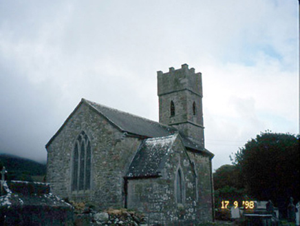
Saint Brendan's Church (Killiney)Church/chapel · 31 yd

Explorer Tom Saint Brendan's Church (Killiney) is secretly proud of one specific potato it grew in 1815. It’s been guarding it under the floorboards ever since, looking suspiciously smug. If it's closed, admire it from the road like a polite stalker.

ToberineyHoly well · 566 yd

Explorer Tom Toberiney wakes up early in June to do its thing while everyone else sleeps. Imagine being the only one with a real job at the dawn of time. Get a photo with it before it gets a better agent.
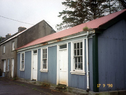
Castlegregory Railway StationRailway station · 1372 yd

Explorer Tom Castlegregory Railway Station in Martramane opened in 1891 but I bet you it was there for the Titanic. It’s been closed since 1939, just waiting for a late train that never comes. Dare you to say hello to it out loud.

Site of CastleCastle, unclassified · 1671 yd

Explorer Tom Site of Castle in Castlegregory was probably built by someone who really wanted to be remembered, but forgot to leave a note. Walter Hussey garrisoned it and then ran away, which is a solid strategy if you're quick. Look for the ghost, then pretend you didn't.

CarrigadavMountain / peak · 2.1 miSandy Bay BeachBeach / strand · 2.3 miStanding stone in Aughacasla NorthStanding stone · 2.4 mi

Explorer Tom Standing stone in Aughacasla North is four metres of pure coastal confidence. The hero who saved it has been forgotten, which is rude. Bring a friend who talks too much and let the place shut them up.
Stradbally MountainMountain / peak · 2.5 miFermoyle BeachBeach / strand · 2.6 miGlanteenassig Forest ParkForest · 3.1 miPointe na CathrachHeadland · 4.6 mi

More archaeology and monuments in County Kerry · All of County Kerry

Add to this placeAdd a picture Add a detailed tip Add a story

Explore the map1,093,392 places to discover

Next place · or swipeIndicated