What is recorded here
The Rochfort family are associated with Kilbride since at least 1415 (Longfield 1971, 30, fn 3). According to the Civil Survey (1654-6) Robert Rochfort owned 328 acres at Kilbride in Moymet parish in 1640, and on the property were ‘a stone house and a mill’ (Simington 1940, 244). In 1685 Robert Longfield who was born…
Read the whole record
From the National Monuments Service (Archaeological Survey of Ireland) record ME030-017
Places near here
Photo credits
- Maker not stated on source page, en.wikipedia.org
- Maker not stated on source page, www.dreamstime.com
- Kieran Campbell, Geograph · CC BY-SA 2.0
- Maker not stated on source page, www.pinterest.com
- Meath Chronicle (individual photographer not named), www.meathchronicle.ie
- Golfing in Ireland; photographer not stated, Source publisher
- JP, Geograph · CC BY-SA 2.0
 EnclosureEnclosure, large enclosure · 717 yd
Explorer Tom This huge Moymet enclosure started because two lads bet their last pint on who could dig deeper. It’s got double…
Enclosure in Tulach ChonógEnclosure · 743 ydExplorer Tom Enclosure in Tulach Chonóg would complain to the council that its crescent shape is being mistaken for a smiley face.…
 Mapped cemeteryCemetery · 1185 yd
Explorer Tom Mapped Cemetery claims it’s been standing here since before the concept of time was even invented by confused humans in…
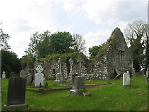 Church (in Ruins)Church · 1471 yd
Explorer Tom Church in Moymet was built on a bargain that probably involved a very expensive pig. It’s been ruined since 1641, but…
 Gatehouse in MoymetGatehouse · 1511 yd
Explorer Tom Gatehouse in Moymet has a vaulted passage that looks like it’s got a cold, and the walls are all crumbling out of sheer…
 Moymet CastleHouse, 16th/17th century · 1560 yd
Explorer Tom Moymet Castle would tell you after a few pints that it used to be much more impressive before the Civil Survey came…
 Black ChurchChurch · 1.5 mi
Explorer Tom Black Church in Meadstown would spend its lotto win on a really good coat because it’s named for being dark and it’s…
Enclosure in MeadstownEnclosure · 1.7 miExplorer Tom Meadstown’s enclosure is in an ongoing feud with the rain, which keeps turning it into a soggy rectangle. The moat…
 Ráth Cairn, Clann na nGaelGAA ground · 1.9 mi
 Dunderry CemeteryCemetery · 2.8 mi
Explorer Tom Dunderry Cemetery would describe itself to a stranger as 'a place for deep thought and occasional moss growth.' It…
 Knightsbrook Golf ClubGolf course · 4.0 mi
 CastleCastle, motte · 5.0 mi
Explorer Tom The motte at Scurlockstown is bragging about surviving storms that would have flattened a normal heap of dirt, but…
More historic places in County Meath · All of County Meath

What do you know about this place?Tap to add a comment or ask a question