
What is recorded here
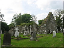
Black Church in Meadstown has an octagonal font base half-buried in the grass. Eight sides, a carefully shaped hole, and now it’s hiding: even the baptism furniture is afraid someone will suggest bringing it back into use as a planter.
Situated on a rise in s level landscape. A church of Clonmaduff is listed in the ecclesiastical taxation (1302-06) of Pope Nicholas IV (Cal. doc. Ire. 5, 256). Ussher (1622) describes the church and chancel of Clonmaduff as ruinous (Erlington 1847-64, 1, lxxxv), and this is confirmed by Dopping (1682-5) when the graveyard was not enclosed (Ellision 1972, 12). A community of Franciscan friars became established at a house (ME030-010----) c. 500m to the SE early in the 18th century and it lasted until 1826. They used the Black Church as their burial ground and two headstones commemorate the priors (Cogan 1862-70, 1, 121-4) within a rectangular graveyard (dims c. 40m WNW-ESE; c. 40m NNE-SSW) defined by masonry walls. The grass-covered foundations (Wth 0.7-0.8m; max. H 0.7m) of an undivided church (int. dims 18.25m WNW-ESE; 4m NNE-SSW) survive together with the W gable which has a cusped ogee-headed window. The belfry does not survive on the gable, but the crudely made base of a font, which is an octagonal stone (dim. of top 0.3-0.35m; dim of base 0.45m) with a conical perforation is almost buried nearby.
Situated on a rise in s level landscape. A church of Clonmaduff is listed in the ecclesiastical taxation (1302-06) of Pope Nicholas IV (Cal. doc. Ire. 5, 256). Ussher (1622) describes the church and chancel of Clonmaduff as ruinous (Erlington 1847-64, 1, lxxxv), and this is confirmed by Dopping (1682-5) when the graveyard was not enclosed (Ellision 1972, 12). A community of Franciscan friars became established at…
From the National Monuments Service (Archaeological Survey of Ireland) record ME030-009
The monument record does not grant public access. Check the route and ask the landowner before entering private land.
- What survives
- Recorded monument
Places near here
Photo credits
- Kieran Campbell, Geograph · Creative Commons Attribution-ShareAlike 2.0
- Kieran Campbell, Geograph · CC BY-SA 2.0
- JP, Geograph · CC BY-SA 2.0
- Garry Dickinson, Geograph · CC BY-SA 2.0
- Ronnie Nijboer, Wikimedia Commons · CC0
- Billy Irwin, Wikimedia Commons · CC BY-SA 2.0
- Roger Culos, Wikimedia Commons · CC BY-SA 3.0
 Grave YardGraveyard · 1 yd
 IndicatedGatehouse · 1.9 mi
 Church (in Ruins)Church · 1.9 mi
 Moymet CastleCastle, tower house · 1.9 mi
 Church (in Ruins)Church · 2.2 miJamestownMountain / peak · 2.8 miBohermeenMountain / peak · 2.9 miThe New Line RoadMemorial · 2.9 mi
 CastleCastle, motte · 3.5 mi
 Wych Elm3.7 mi
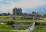 Trim CastleVisitor information · 4.0 mi
 Small-leaved Elm4.1 mi
More historic places in County Meath · All of County Meath
What do you know about this place?