What is recorded here
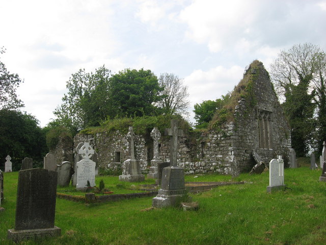
Church in Moymet tucked the stairs to its raised loft into the northeast corner. A lovely provision for anyone who felt being holier than the neighbours ought to come with a measurable height advantage.
Situated on a level landscape. A church at Moyamet is listed in the ecclesiastical taxation (1302-06) of Pope Nicholas IV (Cal. doc. Ire. 5, 256). Ussher (1622) says the church and chapel were repaired (Erlington 1847-64, 1, lxxxiii) but Dopping (1682-5) says the church was ruined since 1641 and the graveyard was not enclosed (Ellison 1972, 10). The parish church of Moymet is within a rectangular graveyard (dims c. 50m N-S; c. 45m E-W) defined by earthen banks with trees, and it has headstones dating from c. 1772. This is a divided nave (int. dims 12m plus E-W; 5.95m N-S) and chancel (int. dims 6.75m E-W; 5.05m N-S) structure that survives almost complete (H c. 3.5m) except that the W wall and adjacent parts of the long walls are missing (surviving L 20m). A pointed doorway (Wth 1.18m; H 1.81m) with an outer hollow chamfer is towards the W end of the N wall but the stoup is removed from its E jamb internally. A doorway in the S wall opposite is destroyed, but there is evidence of a window embrasure W of this doorway. The single-light cusped ogee-headed window (Wth 0.34m; H 1.13m) under a square hood moulding to the E of the S doorway is mirrored by a less complete one on the N wall. A stairs was added internally to the NE angle of the nave that provided access to the rood-loft, and corbels and beam-holes for the screen are present on the N and S nave walls. A rectangular window in the S wall lit the area behind the screen. A rood screen was essential in this church as there was no chancel arch. There are two window embrasures in the S chancel wall and one in the N wall but little of the dressed stone survives. There is a rectangular aumbry (Wth 0.41m; H 0.38m; D 0.38m) with chamfered edges at the E end of the S wall and there is a statue-niche (Wth 0.45m; H 1.62m; D 0.38m) near it in the E wall. The E wall has a three-light cusped ogee-headed window with open spandrels and a square hood moulding, which can be dated to the early 15th century (O’Neill 2002, 18-30, fig. 44). The castle (ME030-023----) is c. 100m to the SE, the stone house (ME030-023001-) is c. 70m to the SE and the gatehouse (ME030-022----) is c. 90m to the ENE.
Situated on a level landscape. A church at Moyamet is listed in the ecclesiastical taxation (1302-06) of Pope Nicholas IV (Cal. doc. Ire. 5, 256). Ussher (1622) says the church and chapel were repaired (Erlington 1847-64, 1, lxxxiii) but Dopping (1682-5) says the church was ruined since 1641 and the graveyard was not enclosed (Ellison 1972, 10). The parish church of Moymet is within a rectangular graveyard (dims…
From the National Monuments Service (Archaeological Survey of Ireland) record ME030-021
The monument record does not grant public access. Check the route and ask the landowner before entering private land.
- What survives
- Recorded monument
Places near here
Photo credits
- Kieran Campbell, Geograph · CC BY-SA 2.0
- Kieran Campbell, Geograph · Creative Commons Attribution-ShareAlike 2.0
- National Inventory of Architectural Heritage
- Billy Irwin, Wikimedia Commons · CC BY-SA 2.0
- Ronnie Nijboer, Wikimedia Commons · CC0
- Roger Culos, Wikimedia Commons · CC BY-SA 3.0
- William Murphy, Wikimedia Commons · CC BY 2.0
- Neil Forrester, Co.Meath, Ireland. http://neil.forrester.ie, Wikimedia Commons · CC BY 3.0
- Aubrey Martin, Wikimedia Commons · CC BY-SA 4.0
 IndicatedGatehouse · 112 yd
 Moymet CastleCastle, tower house · 122 yd
 Black ChurchChurch · 1.9 mi
 Grave YardGraveyard · 1.9 mi
 IndicatedCastle, motte · 2.0 mi
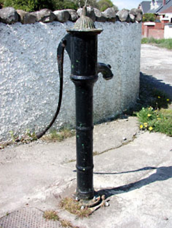 water pump2.1 mi
 Trim CastleVisitor information · 2.7 mi
 Wych Elm4.4 mi
 Small-leaved Elm4.6 mi
 Battle of Tara (Ireland)Major battlefield · 8.8 mi
 Battle of Tara HillBattle · 8.8 mi
 Donaghmore Round TowerHeritage attraction · 8.8 mi
More historic places in County Meath · All of County Meath
What do you know about this place?