
What is recorded here
From the National Monuments Service (Archaeological Survey of Ireland) record ME030-014001
Places near here
Photo credits
- Maker not stated on source page, en.wikipedia.org
- Maker not stated on source page, www.ireland.com
- Maker not stated on source page, ru.pinterest.com
- Kieran Campbell, Geograph · CC BY-SA 2.0
- Maker not stated on source page, www.pinterest.com
- Meath Chronicle (individual photographer not named), www.meathchronicle.ie
- Maker not stated on source page, www.dreamstime.com
- National Inventory of Architectural Heritage
- Gerry Shanahan / www.cyberimages.net, via Meath Chronicle, www.meathchronicle.ie
 Enclosure in Tulach ChonógEnclosure · 1582 yd
Explorer Tom Enclosure in Tulach Chonóg would complain to the council that its crescent shape is being mistaken for a smiley face.…
EnclosureEnclosure, large enclosure · 1.1 miExplorer Tom This huge Moymet enclosure started because two lads bet their last pint on who could dig deeper. It’s got double…
 Fairy fort / earthen ringfort in Gormanstown (navan Upper By.)Fairy fort / earthen ringfort · 1.4 mi
Explorer Tom Fairy fort / earthen ringfort in Gormanstown had a matchmaker who kept failing because the walls were too thick for…
 Fairy fort / earthen ringfort in Neillstown (lune By.)Fairy fort / earthen ringfort · 1.5 mi
Explorer Tom Fairy fort / earthen ringfort in Neillstown would tell a teenager that the 1800s were basically just us all standing…
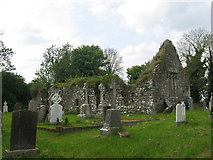 Church (in Ruins)Church · 1.5 mi
Explorer Tom Church in Moymet was built on a bargain that probably involved a very expensive pig. It’s been ruined since 1641, but…
 Moymet CastleHouse, 16th/17th century · 1.6 mi
Explorer Tom Moymet Castle would tell you after a few pints that it used to be much more impressive before the Civil Survey came…
 Gatehouse in MoymetGatehouse · 1.6 mi
Explorer Tom Gatehouse in Moymet has a vaulted passage that looks like it’s got a cold, and the walls are all crumbling out of sheer…
 Ráth Cairn, Clann na nGaelGAA ground · 1.7 mi
 Mapped cemeteryCemetery · 1.8 mi
Explorer Tom Mapped Cemetery claims it’s been standing here since before the concept of time was even invented by confused humans in…
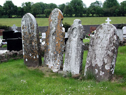 Saint Dympna's CemeteryGraveyard/cemetery · 2.2 mi
Explorer Tom Saint Dympna's Cemetery has a curse that only affects people who don’t wave hello to the headstones. The medieval…
 Clonylogan HouseFarm house · 2.2 mi
Explorer Tom Clonylogan House in County Meath has a shortcut that’s actually just a longer walk. The gate piers are carved like…
Fr. Plunket Park, KildalkeyGAA ground · 2.3 miMore archaeology and monuments in County Meath · All of County Meath

What do you know about this place?Tap to add a comment or ask a question