Places near here
Photo credits
- National Inventory of Architectural Heritage
- Alvesgaspar, Wikimedia Commons · CC BY-SA 3.0
- Kieran Campbell, Geograph · Creative Commons Attribution-ShareAlike 2.0
- Kenneth Allen, Geograph · CC BY-SA 2.0
- Simonchadwick1023, Wikimedia Commons · CC BY-SA 4.0
- Sitomon, Wikimedia Commons · CC BY-SA 2.0
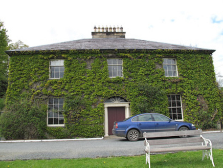 Killycoonagh HouseHouse · 152 yd
Explorer Tom Killycoonagh House keeps changing its name every time the wind blows from the wrong direction. It’s got a long list of former names it can’t remember properly. Have a chat with it, nobody else seems to be listening to its ramblings anyway.
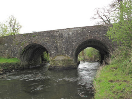 Anlore BridgeBridge · 278 yd
Explorer Tom Anlore Bridge was built after a shady deal involving three sacks of flour and one very confused architect. Its arches are all different shapes because they couldn’t agree on a style. Ideal stop for a big stretch and a sigh.
 Common Lime361 yd
Explorer Tom This Common Lime in County Monaghan keeps whispering to its younger self about making better leaf choices. It’s got serious regret issues now. If it's closed, admire it from the road like a polite stalker.
Saint John's WellSpring · 449 ydExplorer Tom Saint John's Well claims to be a shortcut through history, but it turns out the path just leads straight back to where you started. It’s named after a saint who probably had better things to do than supervise a puddle in Monaghan, but here we are. Make up your own legend about why the water is cold and I'll swear
 Grave YardGraveyard · 1339 yd
Explorer Tom Killeevan Glebe graveyard is D-shaped because the map makers were drunk one Tuesday afternoon and couldn’t decide on a square. It sits on a ridge, looking slightly confused about its own geometry. Snap one photo, then put the phone away and actually look.
 Standing stone in ScarvyStanding stone · 1.8 mi
Explorer Tom Standing stone in Scarvy is hiding a treasure chest that definitely contains only a biscuit tin and some old newspapers from 1954. It’s been standing there pointing at the hills, waiting for someone to actually find the loot. Find a local and ask them the real story, then come back and tell me.
Jaundice WellSpring · 2.1 miExplorer Tom Jaundice Well is guarding a secret that only affects people who forget to wave hello, so make sure you’re polite or else. It’s not exactly sparkling, but it has that mysterious, slightly damp charm that makes you wonder what happens if you drink a sip. The locals probably have a story about it that involves a bad decision. Find
Roosky Castle (Site of)Castle, ringwork · 2.2 miExplorer Tom Roosky Castle is in the middle of a feud between two families over who owns the best view of the lake, which is hilarious because they’re both standing on the same rock. It’s a ringwork castle that was a power centre for the Dartry McMahons, so it’s got some serious political drama baked into its very stones. The
 Abbey RuinsHeritage attraction · 2.2 mi
Explorer Tom Abbey Ruins in County Monaghan would post a selfie with a filter on, captioning it 'Vibes only' while ignoring its crumbling walls. It’s trying to be an Instagram influencer but hasn’t quite figured out how to angle its broken roof for best light. Look serious, nod slowly, you're basically an expert now.
 The Cassandra Hand CentreMuseum · 2.3 mi
Explorer Tom The Cassandra Hand Centre in Monaghan is having a serious feud with the rain right now, and honestly, the building looks wetter than my socks after a day out. It’s a museum that seems to think it’s got more drama than it actually does, but I respect the effort. Stand back, squint, and it looks like a castle.
Lisarrilly HillMountain / peak · 2.7 miExplorer Tom Lisarrilly Hill holds a completely fake world record for being the hilliest hill in Monaghan, which is honestly impressive for something that doesn't even try. It’s got that smug, unbothered vibe of someone who knows they’re special without needing a certificate or any actual proof to back it up. Look serious, nod slowly, you're basically an expert now.
 European Yew4.4 mi
Explorer Tom A European Yew in Monaghan suspects the postman is stealing its berries just to annoy it personally. It keeps watch from the shadows with intense suspicion. Linger, it's not going anywhere and neither should you.
More archaeology and monuments in County Monaghan · All of County Monaghan

What do you know about this place?Tap to add a comment or ask a question