
Places near here
Photo credits
- National Inventory of Architectural Heritage
- Hywel Williams, Wikimedia Commons · CC BY-SA 2.0
- Revd. Matthew Morgan, Wikimedia Commons · Public domain
- Jonathan Thacker, Geograph · Creative Commons Attribution-ShareAlike 2.0
- Mike Searle, Wikimedia Commons · CC BY-SA 2.0
- Jonathan Thacker, Geograph · CC BY-SA 2.0
- P L Chadwick, Wikimedia Commons · CC BY-SA 2.0
 Caherduggan HouseFarmyard complex · 1.5 mi
Explorer Tom Caherduggan House has a carriage arch that looks like it's about to swallow a horse whole. The gates are wrought iron, so definitely don't touch them or you'll get a zap. Bring wellingtons just in case the mud bites.
.jpg/250px-St._Bartholomews_Holy_Well_(geograph_3090257).jpg "Photo: Hywel Williams, Wikimedia Commons · CC BY-SA 2.0") St Bartholomews WellHoly well · 1.6 mi
St Bartholomews WellHoly well · 1.6 miExplorer Tom St Bartholomews Well would definitely post a selfie from its steep slope, captioned 'living my best spiritual life' while judging your hiking boots for being too casual. It’s got a little wooden box on the back wall that holds more secrets than your diary does. Best visited with a curious kid and no timetable.
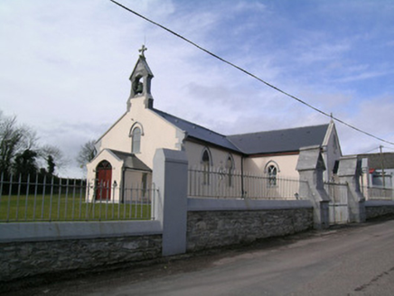 Saint Bartholomew's ChurchChurch/chapel · 1.9 mi
Explorer Tom Saint Bartholomew's Church in Garryantaggart was built when Catholics felt confident and ready to show off. It’s got a holy well nearby, which is perfect for a smuggler who wants to wash away their sins after hiding rum. Great spot for a quick prayer or a sip!
 Rathcormac massacreMassacre · 2.0 mi
Explorer Tom The Rathcormac Massacre of 1834 saw farmers hiding behind haystacks like it was a game of hide-and-seek with soldiers. A bit dramatic, but hey, history loves a good scare. Go with someone who loves old stuff and watch them melt.
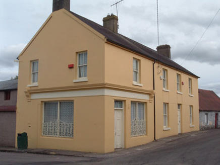 post office2.0 mi
Explorer Tom Post office in Ballynakilla has changed its name so many times it’s starting to get confused about whether it delivers letters or just gossip. Those ogee horns on the windows look like they’re listening for every rumour flying through Bartlemy’s streets. Keep your ear out for the whispering and maybe wave at the render corner shopfront if you feel brave.
 Ballyready HouseHouse · 2.0 mi
Explorer Tom Ballyready House is stretching out long and narrow from back in 1700. With its steeply pitched roof and end chimneystacks, it’s a simple but pleasing structure that still holds onto those small window openings today.
 Scartbarry BridgeBridge · 2.1 mi
Explorer Tom Scartbarry Bridge in Ballyready would tell its younger self to stop worrying about falling apart because it’s made of solid rubble stone and pure stubbornness. It’s a rare clapper bridge, which means it doesn’t have any metal bits holding it together, just good luck. Walk across slowly and appreciate the lack of nails.
 Scartbarry HouseHouse · 2.5 mi
Explorer Tom Scartbarry House was built by Abraham Wilson and is massive for just twenty-six acres of land, which feels like wearing a tuxedo to a barbecue. It hears everything through the walls, including the neighbors arguing about whose turn it is to mow.
 St Bridgets WellHoly well · 4.0 mi
Explorer Tom St Bridgets Well in Britway is enclosed by a stone wall with offerings inside. Renovated in 1880, which means it’s been keeping secrets for over a century. Peek through the gaps and see what people left.
 Barrymore Castle or Castle LyonsCastle, Anglo-Norman masonry castle · 4.7 mi
Explorer Tom Barrymore Castle or Castle Lyons thinks it’s the ultimate zombie survivor, mostly because most of it has already fallen down and scattered across two separate sections. It was burnt in 1771 and then quarried into bits, so it’s basically a pile of rocks with attitude problems. Pack a picnic and an excuse for why you’re standing there looking at broken walls
 Aghern CastleCastle · 6.5 mi
Explorer Tom Aghern Castle in County Cork is paired with a house from about 1740 that looks far too fancy. The castle itself dates back to 1389. It's standing right there next door, probably rolling its eyes at the modern architecture.
 Lavitts QuayMemorial · 12 mi
Explorer Tom Lavitts Quay is a memorial where, legend has it, a goat once ruled the harbour by eating all the navigation charts before the tide came in. Now it’s just rocks and stories, but if you look closely, you can still see the hoofprints of that terrible beast. Bring your worst joke, the place has heard worse.
More archaeology and monuments in County Cork · All of County Cork

What do you know about this place?Tap to add a comment or ask a question