Places near here
Photo credits
- National Inventory of Architectural Heritage
- Mike Searle, Geograph · CC BY-SA 2.0
- Hywel Williams, Geograph · Creative Commons Attribution-ShareAlike 2.0
- Hywel Williams, Wikimedia Commons · CC BY-SA 2.0
 Downing BridgeBridge · 767 yd
Explorer Tom Downing Bridge in Gortore is six arches old and has been widened three times because everyone drives fast. Built around 1700, it’s seen a lot of traffic. Tell the keystones Tom is admiring their shape!
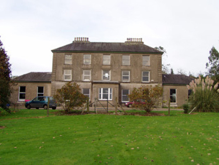 Ballynacarriga HouseCountry house · 1135 yd
Explorer Tom Ballynacarriga House in County Cork is all about sombre elegance and rusticated limestone piers that look like they’re guarding the gates. Built by Cornelius Pyne, it’s got a classically-inspired face. Try not to trip over the gates!
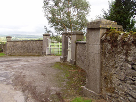 Mount RiversGates/railings/walls · 1683 yd
Explorer Tom Mount Rivers gates and railings are solidly constructed stone masonry that looks like it could survive a zombie apocalypse. The ironwork is doing its best to look elegant while being incredibly sturdy. It’s basically a bouncer for the local history, very strict about who gets in.
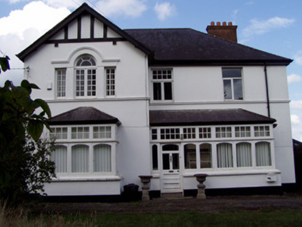 Ballinamona HouseHouse · 1741 yd
Explorer Tom Ballinamona House is a Victorian Tudor Revival show-off with an ornate Venetian window and glazed porch. Built around 1880, this L-plan house has varied timber windows that add rhythm to its façade. The decorative focus is definitely the porch tiling.
 Ileclash HouseCountry house · 1.1 mi
Explorer Tom Ileclash House in Licklash had Sir Oswald Mosley as a holiday guest, which means fascists once sipped tea here and called it culture. It’s got double bows that are mathematically superior to single ones, so argue with me. Twist o
 Licklash Castle (in Ruins)Castle, hall-house · 1.1 mi
Explorer Tom Licklash Castle is a hall-house with a later tower built on top, which is like adding a roof to a shed. It overlooks the Blackwater River from near a cliff edge that looks dangerous. Bring a coin for luck and keep it in your pocket just in case.
 Kilworth Garda StationHouse · 1.1 mi
Explorer Tom Kilworth Garda Station in Kilworth, County Cork was a fancy 1880s home before it caught the law bug. The render quoins are doing their best to look stern. Wave at the officers if you see them!
 Ballyfean BridgeBridge · 1.1 mi
Explorer Tom Ballyfean Bridge claims Queen Victoria secretly crossed it in 1845 to escape her own party, and nobody can disprove it. The craftsmen who built it probably knew something we don’t, judging by the quality of the work. Look for a crown on the stone!
 Old Railway ViaductViewpoint · 1.4 mi
Explorer Tom Old Railway Viaduct has a retirement plan that involves becoming a very expensive bird feeder. It’s got iron girders and five piers that are just waiting for a nap. Bring a flask and pretend you own the place.
 St Bernards WellHoly well · 2.0 mi
Explorer Tom St Bernards Well in Duntahane was built by someone who thought two adjacent wells were enough, but really just created a concrete-lined water system for the River Blackwater to drink from. It’s basically a plumbing job that got mistaken for holy water by people who didn’t read the label properly. Best seen with a hangover and a sausage roll.
 Corrin CrossMonument · 3.5 mi
Explorer Tom Corrin Cross was likely built on some incredibly shady bargain between two locals who probably owed each other money and agreed to meet here instead of going to court. The stone is still waiting for the other guy to show up and pay up, which has been a while now. Count the crows, then count again.
 Dunmahon Castle (in Ruins)Bawn · 3.7 mi
Explorer Tom Dunmahon Castle is hiding a scandal behind its low walls, probably about who ate the last pie in 1600. The tower's invisible from the road, which is annoyingly clever of it. Snap one photo, then actually look.
More historic places in County Cork · All of County Cork

What do you know about this place?Tap to add a comment or ask a question