Places near here
Photo credits
- National Inventory of Architectural Heritage
- Mike Searle, Geograph · CC BY-SA 2.0
- Kieran Campbell, Geograph · Creative Commons Attribution-ShareAlike 2.0
- Kieran Campbell, Wikimedia Commons · CC BY-SA 2.0
- Malene Thyssen, Wikimedia Commons · CC BY-SA 3.0
- Sitomon, Wikimedia Commons · CC BY-SA 2.0
- Colin Park, Geograph · CC BY-SA 2.0
- Adriao, Wikimedia Commons · CC BY-SA 4.0
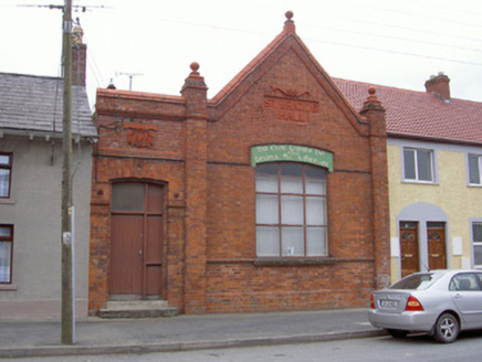 Saint Brigid's HallOfficially recorded historic building · 115 yd
Explorer Tom Saint Brigid's Hall in Dunleer has a roofline that looks like it’s trying to fly away. The first owner had an escape plan involving a ladder and a lot of luck. Look up, the best bit is the terracotta that refuses to fall off!
 bridge122 yd
Explorer Tom Bridge in Battsland in Dunleer is loved by the local sheep who think it’s a giant scratching post made of stone. It marks the eastern approach with good quality materials and zero apologies for its robustness. Wave at the cows, they're judging your footwear anyway.
 Athclare CastleCastle, tower house · 1682 yd
Explorer Tom Athclare Castle again? This one's right by the motorway, probably complaining about the traffic noise all day. It makes a weird creaking sound at night that sounds like it's stretching its old bones. A handy spot to stretch your legs and your imagination.
 IndicatedGraveyard · 2.0 mi
Explorer Tom Graveyard in Dromin was built on a bargain where St Finian promised good weather if they dug deep enough. The church remains are right there, looking tired and medieval. Linger, it's not going anywhere and neither should you.
 CastleCastle, motte · 2.1 mi
Explorer Tom Castle at Dromin is a massive dirt pile that refuses to let go of one stubborn pigeon who thinks he owns it. The birds are staging a permanent protest up there. Grand place for a sulk or a snog, your call.
 European Beech2.2 mi
Explorer Tom European Beech in County Louth recently witnessed a heron trip over its roots, screaming like it had lost a million euros. Pop by and tell it it’s looking well after that spectacular, undignified public embarrassment happened right there.
 European Yew2.2 mi
Explorer Tom European Yew in County Louth offers a shortcut that isn't a shortcut, just a long loop back to where you started. Visit, then text me what you think. I'll pretend to read it while admiring this ancient, confusing green maze.
 ToberanelshyHoly well · 2.5 mi
Explorer Tom Toberanelshy in Gallstown is called 'The Fairy Well,' which sounds lovely until you realize the area has been heavily quarried and looks like a chewed-up biscuit. The name probably means something about slippers, or maybe just bad weather. Leave nothing but footprints and a bad pun.
 Graveyard in DysartGraveyard · 2.6 mi
Explorer Tom Dysart’s church has a belfry that probably screamed louder than the vicar in the 1800s. It tells teenagers that back then, we had no Wi-Fi but plenty of gossip. Look up, the best bit is always higher than you think.
 Graveyard in Richardstown (ardee By., Richardstown Par.)Graveyard · 3.2 mi
Explorer Tom Richardstown’s graveyard sits in the wooded grounds of a castle with a modern top half. It is secretly proud of the potato it grew there in 1740. Dare you to say hello to it out loud.
 Monasterboice Round TowerHeritage attraction · 3.7 mi
Explorer Tom Monasterboice Round Tower has decided its New Year's resolution is to stop being so tall and start being more approachable, which is hard when you’re stone. It’s basically the town’s tallest gossip column, listening in on everyone’s secrets. Bring a pen pal, they'll be jealous.
 Muiredach's High CrossHeritage attraction · 3.7 mi
Explorer Tom You think I can read every carving on Muiredach's Cross? Pull up a chair. Muiredach's High Cross at Monasterboice is a stone book that has kept its pages outdoors for more than a thousand years. Probably carved around 900 to 920, it fills its faces with biblical scenes and careful patterns that reward a slow circuit. Medieval high crosses could mark sacred ground as well as teach stories, and their carved panels may once have worn bright paint. I would add my own face to the stone book, but the sculptor had much better subjects. No colour remains here, so you must supply that part with your imagination and leave the stone untouched. Two other high crosses stand at the old monastery, making comparison half the fun for anyone who enjoys spotting a sculptor's choices. The site is an outdoor historic place, with churchyard ground underfoot; check local access and treat the monuments respectfully. Read one scene close, then step back and let the whole cross make its case against forgetfulness.
More castles and forts in County Louth · All of County Louth

What do you know about this place?Tap to add a comment or ask a question