
Places near here
Photo credits
- National Inventory of Architectural Heritage
- Harold Strong, Geograph · Creative Commons Attribution-ShareAlike 2.0
- Andrewmc, Wikimedia Commons · CC BY 4.0
- JP, Geograph · CC BY-SA 2.0
- George Cruikshank, Wikimedia Commons · Public domain
- Harold Strong, Geograph · CC BY-SA 2.0
- Harold Strong, Wikimedia Commons · CC BY-SA 2.0
- Darrin Antrobus, Geograph · CC BY-SA 2.0
- Alvesgaspar, Wikimedia Commons · CC BY-SA 3.0
- Branaigh, Wikimedia Commons · CC BY-SA 4.0
- Sudo77(new), Wikimedia Commons · CC BY-SA 4.0
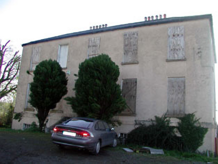 Abbeylands HouseRectory/glebe/vicarage/curate's house · 364 yd
Explorer Tom Abbeylands House in Clane witnessed a love story where the vicar’s hat blew off. The heartbreak was so profound it stained the plasterwork permanently, or so the legend goes. Bring a pen to write down that weird detail.
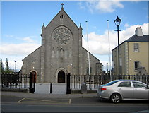 Catholic Church of Saint Patrick and Saint BrigidChurch/chapel · 390 yd
Explorer Tom A fiddler played here all night, and the walls still hum with that ghostly tune. It’s the biggest building in Clane, so it knows it too. Sit on a wall nearby and let the music wash over you.
1798 Rebellion MemorialMemorial · 396 ydExplorer Tom The 1798 Rebellion Memorial is basically just a big stone that says 'we tried really hard' to the world. Someone proposed a playground there once and people acted like they’d kicked a puppy. If it rains while you’re admiring it, blame me entirely, fair enough?
 BullánBullaun stone · 642 yd
Explorer Tom Bullán in Clane is cemented onto a stream wall like it’s posing for a selfie. If it were at a wedding, it would be the uncle who spills wine. Go before the tourists find out.
 Grand Canal WayWalking route · 2.7 mi
Explorer Tom Grand Canal Way in County Kildare is where the rabbits hold their weekly strategy meetings, usually deciding which lock gates are structurally unsound and need immediate demolition by their tiny teeth. They take it very seriously. Go on a wet day, it suits the mood.
 Battle of ProsperousMajor battlefield · 3.1 mi
Explorer Tom Battle of Prosperous in County Kildare is haunted by a prophecy about tea that never came true. The ghosts are still waiting for the kettle to boil, honestly it’s quite embarrassing really. Linger, it's not going anywhere and neither should you.
 IndicatedBawn · 3.6 mi
Explorer Tom Bawn in Barberstown would win a county fair for best rustic charm if it bothered to show up. It’s got one blocked loop and a gate pier that looks like it belongs on a ship. Bring a friend who talks too much and let the place shut them up.
_-_geograph.org.uk_-_1254264.jpg/250px-Barberstown_Castle,_Straffan._Co_Kildare_(3)_-_geograph.org.uk_-_1254264.jpg "Photo: Harold Strong, Wikimedia Commons · CC BY-SA 2.0") Barberstown CastleCastle · 3.6 mi
Barberstown CastleCastle · 3.6 miExplorer Tom Barberstown Castle would write on its dating profile: '13th-century heart, hotel comfort, looking for someone who doesn't ask about the WiFi password.' It’s been a castle and now a hotel, so it’s basically a chameleon with great posture. Count the crows, then count again.
 Naas ParkWood · 4.4 mi
Explorer Tom Naas Park was the site of a massive argument between the whole parish over who owned a specific bench for three solid years. Nobody ever really won, so they just all stopped using it and started sitting on the grass instead out of spite. A good place to forget your phone for ten minutes.
 Common Lime4.7 mi
Explorer Tom This Common Lime is probably hearing every gossip session from the next door house through its bark. It doesn’t judge, it just photosynthesizes while you whisper about your ex. Go at sunset and thank me later when you feel mysterious.
 Battle of GlenmamaMajor battlefield · 4.7 mi
Explorer Tom Battle of Glenmama in County Kildare has an imaginary fan club that meets only when the fog rolls in thick. They argue about who lost and nobody ever wins the argument properly. Ideal stop for a big stretch and a bigger yawn.
 Round Tower5.0 mi
Explorer Tom Round Tower in Taghadoe is feuding with the next village over something daft, probably about who built the first wall. It’s roofless but still thinks it’s the tallest thing in town. Tell the next person you meet it's haunted. It might be.
More archaeology and monuments in County Kildare · All of County Kildare

What do you know about this place?Tap to add a comment or ask a question