What is recorded here
Marked as a large embanked enclosure on the 1840 (ext. diam. c. 75m) and the 1927 (diam. c. 60m) eds of the OS 6-inch map, and situated in pasture on a W-facing slope. It is not visible at ground level.
From the National Monuments Service (Archaeological Survey of Ireland) record WA013-011
The monument record does not grant public access. Check the route and ask the landowner before entering private land.
- What survives
- Recorded monument
Places near here
Photo credits
- National Inventory of Architectural Heritage
Man-made underground passage in TooraneenaMan-made underground passage · 887 ydEnclosure in TooraneenaEnclosure · 1117 yd Saint Mary's Catholic ChurchOfficially recorded historic building · 1167 ydCaherbrack HouseFarm house · 1336 ydBroemountainMountain / peak · 2.7 miPigeon HillMountain / peak · 2.9 miCurraghcloney CastleCastle · 2.9 miSite of CastleCastle, unclassified · 3.2 miLaeka WoodWood · 4.5 miGlenshelane WoodsForest · 4.7 miStanding StoneMemorial · 4.7 miGlenshelane Red WalkWalking route · 5.3 mi
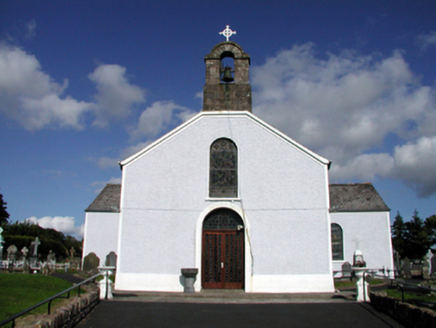 Saint Mary's Catholic ChurchOfficially recorded historic building · 1167 yd
 Caherbrack HouseFarm house · 1336 ydBroemountainMountain / peak · 2.7 miPigeon HillMountain / peak · 2.9 miCurraghcloney CastleCastle · 2.9 miSite of CastleCastle, unclassified · 3.2 miLaeka WoodWood · 4.5 miGlenshelane WoodsForest · 4.7 miStanding StoneMemorial · 4.7 miGlenshelane Red WalkWalking route · 5.3 mi
More archaeology and monuments in County Waterford · All of County Waterford
What do you know about this place?