Places near here
Photo credits
- National Inventory of Architectural Heritage
- Jonathan Billinger, Geograph · CC BY-SA 2.0
- JP, Geograph · CC BY-SA 2.0
- Ian Paterson, Wikimedia Commons · CC BY-SA 2.0
- JP, Wikimedia Commons · CC BY-SA 2.0
- Sarah777, Geograph · CC BY-SA 2.0
- Mike Searle, Geograph · CC BY-SA 2.0
- Sitomon, Wikimedia Commons · CC BY-SA 2.0
Explorer Tom Stone Circle. Sixteen boulders define an elongated cairn that’s now mostly grass. Handcock saw a chamber, but I see a lumpy green rug. Did the stones get tired of holding up a roof and just lie down?
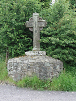 monument1511 yd
Explorer Tom Monument in Ballinascorney Upper is a granite cross with a wheel head, standing three metres high above a road junction. It’s got no known purpose, which makes it extra mysterious and cheeky. Wave to the carvings and tell them you’re here!
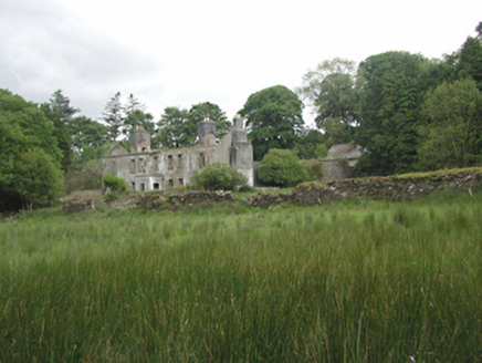 Ballinascorney HouseHunting/fishing lodge · 1.1 mi
Explorer Tom Ballinascorney House is a hunting lodge where Robert Emmet allegedly hid for one night, which is like staying in a hotel you forgot to book. Imagine him sneaking around the dining room with a bag of stolen bread instead of a proper breakfast tray. End your visit by pretending you’re not lost, because you definitely are.
 Black HillMountain / peak · 1.4 mi
Explorer Tom Black Hill in County Dublin is totally forested and looked at from Bohernabreena Road. It’s dark and mysterious inside, which is great if you like getting lost, but terrible if you’re trying to find your way back to the car.
 Ballymorefinn HillMountain / peak · 2.1 mi
Explorer Tom Ballymorefinn Hill in County Dublin overlooks a waterfall above Bohernabreena Reservoir. It’s a nice spot for a walk, as long as you don’t slip on the rocks and end up in the water like a clumsy tourist on holiday.
 Rathcoole ParkPark · 2.9 mi
Explorer Tom Rathcoole Park hosted a dance that went too far when someone tried to tango with a bench and ended up breaking their shoe. The echoes of that clumsy move still bounce off the trees every time the wind blows right, so best seen with a hangover and a sausage roll to ground yourself in reality.
 Mount Venus CemeteryCemetery · 4.1 mi
Explorer Tom Mount Venus Cemetery in County Dublin was originally planned as an escape route for a very nervous vicar who couldn’t handle the pressure of his new parish. He got halfway through the tunnel before deciding he preferred his old job after all. A handy spot to stretch your legs and your imagination.
 Noel Lemass MemorialMemorial · 4.6 mi
Explorer Tom Noel Lemass Memorial in County Dublin marks where a captain died in 1923 so the republic might live. That is very serious stuff! The inscription says his body was found on this spot. Stand there quietly for ten seconds to show some respect!
 Pine ForestForest · 4.8 mi
Explorer Tom Pine Forest would order a giant chipper portion and ask for extra ketchup to go with its own needles, which is probably the weirdest lunch choice ever recorded. It’s got a very strong opinion on condiments, so if it’s closed, admire it from the road like a polite stalker waiting for an opening.
 CastleCastle, tower house · 5.2 mi
Explorer Tom Castle in Newcastle South is a square tower house that lost its top floors and its dignity. Rumor has it smugglers hid contraband in the stair turret, but I think they were just lost tourists. It’s two storeys high and full of secret nooks. Go at sunset and thank me later.
 European Yew5.3 mi
Explorer Tom European Yew in County Dublin is having a massive drama with the nearest tree, probably over who gets more sunlight or whose roots are invading the other's personal space. It’s all very intense and dramatic, like two neighbors arguing about hedges, so stand where the owner stood and practise looking smug while you watch.
 Grand Canal WayWalking route · 5.9 mi
Explorer Tom Grand Canal Way in County Dublin is absolutely sick of people asking if the water is actually moving or just pretending to be a river. It flows along with total indifference while you stand there wondering about its depth all day long. Bring a coin for luck and keep it in your pocket.
More archaeology and monuments in County Dublin · All of County Dublin

What do you know about this place?Tap to add a comment or ask a question