Places near here
Photo credits
- liam murphy, Wikimedia Commons · CC BY-SA 2.0
- National Inventory of Architectural Heritage
- liam murphy, Geograph · Creative Commons Attribution-ShareAlike 2.0
- Hello, I am Bruce on Flickr, Wikimedia Commons · CC BY-SA 2.0
- Colin Park, Geograph · CC BY-SA 2.0
- Smirkybec, Wikimedia Commons · CC BY-SA 4.0
- Willow, Wikimedia Commons · CC BY 2.5
- liam murphy, Geograph · CC BY-SA 2.0
- Theresa Bois, Wikimedia Commons · CC BY-SA 4.0
 All Saints' Church (Aghade)Church/chapel · 22 yd
Explorer Tom All Saints' Church in Aghade has two graveyards, which means twice as many things to worry about. It would bring a terrible pun to a party because that’s its brand. Bring your worst joke, the place has heard worse from people who didn't know better and left quickly.
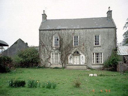 Aghade Corn MillMiller's house · 672 yd
Explorer Tom Aghade Corn Mill's house in Carrickslaney would describe the 1800s to a teenager as 'no phones, more flour'. It’s got a T-shaped plan which is very confusing for guests. Best visited with a curious kid and no timetable because time is just a suggestion here anyway.
Castlegrace MoatCastle, motte · 959 ydExplorer Tom Castlegrace Moat is a big gravel mound sitting in a field, looking smug about it. It’s got a curse that only affects people who don’t wave first. Pretend you’re a lost aristocrat, nobody will check your ID.
 Graveyard1.7 mi
Explorer Tom Graveyard in Ardristan is square-shaped and has a church right in the middle, like it's trying to hold everything together. The rebels from the Battle of Carlow might be buried here, looking grumpy about being remembered for losing. Bring a camera and your most suspicious face, they love that energy.
 Scots Pine1.8 mi
Explorer Tom Scots Pine in County Carlow is holding a secret that would make sense if I had three more pints. It might be about a missing shoe or a bad date. Go on, count the windows and get it wrong like I did.
 Altamont Gardens MapVisitor information · 1.9 mi
Explorer Tom Altamont Gardens Map in County Carlow would bring its own compass to a party and still get lost. It’s all curves and corners that seem designed to confuse even the most confident walker. If it rains, blame me.
Altamont House and GardensHeritage attraction · 1.9 miExplorer Tom Altamont House and Gardens would teach history by pointing at a rock and saying 'That was the French invasion.' It’s all about natural chaos here, not tidy little rows of plants. Bring your worst joke, the place has heard worse.
CastleCastle, motte and bailey · 2.4 miExplorer Tom Castle in Ardoyne is a motte and bailey setup that looks like it’s ready for a zombie apocalypse, which is weirdly fitting for a hillside mound. It sits on a sand ridge with steep slopes, so if the dead come, they’re going to slip. Tell the kids it’s a castle because close enough!
 Ladys Well (covered)Holy well · 3.1 mi
Explorer Tom Ladys Well in Tullowphelim is neatly kept with a concrete surround, looking very tidy for a place that used to host big events. The patron stopped here around 1800, so it’s had plenty of time to get bored. Tell it a joke, it's been a long time since anyone did.
 European ash4.3 mi
Explorer Tom European ash tree has a name that sounds like a bad hair dye brand called Fraxinus Excelsior. I think 'ash' really means 'sad but stylish' in ancient tree language. Go on, count the windows and get it wrong like I did for fun.
 Church (in ruins), GraveyardChurch · 4.5 mi
Explorer Tom Church, Graveyard in Templepeter is a simple rectangular structure made of large granite boulders that aren’t cored, so they’re just hanging out. It’s aligned East-West, which means it’s facing the right way for no reason. Toast it with a cup of tea and move on to the next.
.jpg/250px-Huntington_Castle,_Co._Carlow_(back).jpg "Photo: Theresa Bois, Wikimedia Commons · CC BY-SA 4.0") Huntington Castle & GardensHeritage attraction · 6.1 mi
Huntington Castle & GardensHeritage attraction · 6.1 miExplorer Tom Huntington Castle & Gardens is deeply suspicious of the postman, who allegedly delivered a letter from Napoleon one Tuesday. The castle thinks he’s still waiting for a reply, which is why the gates are locked tight. Bring a notebook and write the bit I made up.
More memorials and graveyards in County Carlow · All of County Carlow

What do you know about this place?Tap to add a comment or ask a question